Saticoy Oil Field facts for kids
Quick facts for kids Saticoy Oil Field |
|
|---|---|

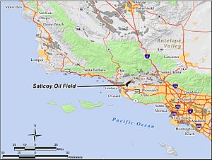
The Saticoy Oil Field in Ventura County, California. Other oil fields are shown in dark gray.
|
|
| Country | United States |
| Region | Ventura Basin Province |
| Location | Ventura County, California |
| Offshore/onshore | onshore |
| Operator | Vintage Production |
| Field history | |
| Discovery | 1955 |
| Start of development | 1956 |
| Peak year | 1958 |
| Production | |
| Current production of oil | 113.4 barrels per day (~5,651 t/a) |
| Estimated oil in place | 0.387 million barrels (~52,800 t) |
| Producing formations | Pleistocene Santa Barbara Formation, Upper Pliocene Pico Sand |
The Saticoy Oil Field is a place in Ventura County, California, where oil and natural gas are found deep underground. It's a long, narrow area that runs next to the Santa Clara River, close to the town of Saticoy.
This oil field was discovered in 1955. It's smaller than some other fields in the area, but it has produced a good amount of oil. In early 2009, experts thought there were still about 387,000 barrels (61,500 m3) of oil that could be taken out. This was out of an original 23.5 million barrels. At that time, 15 wells were still working. Vintage Production, a company owned by Occidental Petroleum, was the main operator of the field in 2009.
Contents
Where is the Saticoy Oil Field?
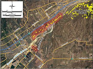
The Saticoy Oil Field is shaped like a long, thin strip. It follows a natural break in the Earth called the Oak Ridge Fault. This fault also shapes how the Santa Clara River flows, running from the northeast to the southwest.
The field is about four miles long and a quarter-mile wide. This covers about 640 acres where oil can be found. Most of it is on the northwest side of the Santa Clara River. California State Route 126 runs alongside the field for its whole length.
Other oil fields are nearby. The large South Mountain Oil Field is next to it on the northeast. The Santa Clara Avenue Oil Field and Oxnard Oil Field are south of the river.
The Area Around the Field
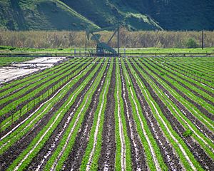
The land around the Saticoy Oil Field is mostly used for farming. You can see oil wells and equipment mixed in with farm fields and fruit orchards. The weather here is like the Mediterranean, with cool, rainy winters and warm, dry summers. The summer heat is often made milder by morning fog from the coast.
About 15 inches of rain fall each year, mostly in winter. The average temperature is between 56 °F (13 °C) and 60 °F (16 °C). It rarely freezes. The field is mostly flat because it's in the Santa Clara River's floodplain. Water from the field flows into the river, which then goes west to the Pacific Ocean.
How the Saticoy Oil Field Formed
The Saticoy field is part of the Ventura Basin in southern California. This area is like a big bowl in the Earth's crust that formed a long time ago. The Ventura Basin has very rich farmland because of thick soil left by thousands of years of floods from rivers.
This basin is filled with layers of sedimentary rock. These are rocks formed from sand, mud, and other materials that settled over time. The Oak Ridge Fault cuts through these layers from northeast to southwest.
Trapping Oil Underground
In the Saticoy field, oil is trapped in two main ways. Sometimes, the layers of rock that hold oil get squeezed and bent, creating pockets where oil can collect. Other times, the oil-rich layers end suddenly against the Oak Ridge Thrust Fault. This fault acts like a wall, stopping the oil from moving further up.
The Oak Ridge Fault also shapes the Santa Clara River and the hills south of it. This fault was involved in the 1994 Northridge earthquake. Many of the rock layers that hold oil are almost straight up and down, especially deeper underground. These layers are mostly made of a type of rock called turbidites, which formed from underwater landslides.
The oil in this field is found in different layers of rock. The top layer is called the Pleistocene Santa Barbara Formation. Below that are several layers in the Upper Pliocene Pico Sand. Most of the oil is found between 6,000 and 9,000 feet (1,800 and 2,700 m) below the ground.
The oil found here is of medium quality and has low sulfur. This means it's good for making gasoline and other products. The oil's thickness (called API gravity) is between 30 and 36. The shallowest oil is about 6,350 feet (1,940 m) deep, and the deepest is around 9,035 feet (2,754 m) deep.
History of Oil Production
Shell Oil Co. drilled the first well in the Saticoy field in May 1955. They drilled very deep, reaching 12,020 feet. It was unusual because the deepest oil layers were found first. By August 1956, Shell had found all the other oil layers. The field was developed quickly after that. Oil production reached its highest point in 1958, producing about 2.8 million barrels (450×103 m3) of oil that year.
As the amount of oil coming out naturally started to drop, Shell began a process called waterflooding. This involves pumping water into the ground to push more oil out. Waterflooding was used from 1963 to 1968 in several oil layers.
Changes in Ownership
Shell owned most of the field until 1984. Then, they sold it to Sage Energy. During this time, many big oil companies were selling their operations in California to smaller companies. They wanted to focus on more profitable projects in other countries.
Sage Energy owned the field until 1990, when they sold it to Whiting Petroleum Corp. Whiting then sold some active wells to Crimson Resource Management Corp. in 1994. Crimson operated the field until 2002, selling their 41 remaining wells to Bentley-Simonson. Bentley-Simonson owned it until April 2005, selling to Plains Exploration & Production. Plains operated the field for just over a year, selling the 14 remaining active wells to Vintage Production in October 2006. Vintage Production is the current operator.
As of 2010, there were 15 wells left in the field. Vintage operated 14 of them, which were still active. The other well, owned by Ibsen Resource Management, Inc., was not being used. The 14 Vintage wells were each producing about 8.1 barrels per day (1.29 m3/d) of oil on average.
Images for kids
 | Kyle Baker |
 | Joseph Yoakum |
 | Laura Wheeler Waring |
 | Henry Ossawa Tanner |


