Santa Clara Avenue Oil Field facts for kids
Quick facts for kids Santa Clara Avenue Oil Field |
|
|---|---|

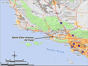
The Santa Clara Avenue Oil Field in Ventura County, California.
|
|
| Country | United States |
| Region | Ventura Basin |
| Location | Ventura County, California |
| Offshore/onshore | onshore |
| Field history | |
| Discovery | 1972 |
| Start of development | 1972 |
| Start of production | 1972 |
| Peak year | 1977 |
| Production | |
| Current production of oil | 211 barrels per day (~10,500 t/a) |
| Year of current production of oil | 2009 |
| Estimated oil in place | 1.335 million barrels (~1.821×10⁵ t) |
| Producing formations | Sespe Formation |
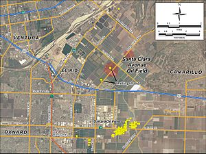
The Santa Clara Avenue Oil Field is a place in Ventura County, California, where oil is found deep underground. It's about six miles southeast of the city of Ventura and four miles northeast of Oxnard. All the oil is taken out using special wells drilled from two small areas called "drilling islands" along Santa Clara Avenue. These wells drill sideways and downwards to reach the oil.
The field is in a farming area, but cities are growing closer to it. In 2010, experts believed there were still about 1,335,000 barrels of oil that could be taken out. At that time, 18 wells were actively pumping oil.
Contents
Where is the Santa Clara Avenue Oil Field?
The oil field is located in the Oxnard Plain, which is a very fertile farming area. Cities like Oxnard, Ventura, and Camarillo are expanding, and their buildings are getting closer to these farmlands. Around the oil pumps and storage tanks, you'll see fields growing onions, broccoli, and strawberries.
U.S. Highway 101 runs along the south side of the oil field. Santa Clara Avenue goes through the field from southwest to northeast, ending at California State Route 118. The small town of El Rio is to the west, and Nyeland Acres is to the south, next to Oxnard. The entire area where oil is produced covers about 180 acres.
Climate and Landscape
The weather here is like a Mediterranean climate, which means cool, rainy winters and warm, dry summers. During the summer, the heat is often made milder by fog and low clouds from the coast in the mornings.
About 15 inches (380 mm) of rain falls each year, mostly in the winter. The average yearly temperature is between 56 and 60 degrees Fahrenheit (13 to 16 degrees Celsius). It rarely freezes. The land is mostly flat, about 80 feet (24 meters) above sea level. Water from the area flows south into Calleguas Creek, then to Mugu Lagoon, and finally into the Pacific Ocean.
How Oil Formed Here
The Santa Clara Avenue oil field is part of the Ventura Basin in southern California. This area is like a giant bowl that sank downwards a long, long time ago, during a period called the late Pliocene (about 5 million years ago). Over millions of years, up to seven kilometers (about 4.3 miles) of sedimentary rock filled this basin. Most of these rocks came from the ocean.
Sometimes, igneous rock (rock formed from cooled lava or magma) from the Conejo Volcanics series is found on top of these sedimentary layers. Oil often collects in the Ventura Basin in places where the rock layers are folded upwards, like an upside-down U-shape (called an anticline), and where there are also cracks in the rock (called faults).
Trapping the Oil
Oil is found when there are sandy rocks with lots of tiny spaces (called porosity) that can hold the oil. The way the rock layers are shaped and arranged (called stratigraphy) helps trap the oil as it tries to move upwards. In the Santa Clara Avenue field, the oil is trapped in many thin layers of oil-rich sand within a rock formation called the Sespe Formation. This formation is from a time called the Oligocene period.
The oil gets trapped because it runs into the Conejo Volcanics, which are igneous rocks that oil cannot pass through. Scientists first thought these igneous rocks filled an ancient canyon, but now they believe it was magma that cooled quickly underground.
Because the surface of the Oxnard Plain is flat, it didn't show any signs of oil underground. Even though oil was found in nearby areas like the Oxnard Oil Field, Ventura Oil Field, South Mountain Oil Field, and Saticoy Oil Field, this field wasn't discovered until 1972. Explorers found it while looking at the edge of a geological feature called the Epworth Syncline.
Two main areas with oil were found, both in the Sespe Formation, separated by the igneous rock. The first discovery was in January 1972, and the second was in July 1973. The oil is found very deep underground – about 9,000 feet (2,743 meters) in one area and 8,600 feet (2,621 meters) in the other. The oil is generally medium-thick and contains about two percent sulfur.
History of Operations
The first well that found oil in this field was drilled by McCulloch Oil Corp. in 1972. Other oil companies quickly explored the area and found the second oil-rich spot about a year and a half later. Over the years, companies like Tenneco Oil Co., ARCO, Chevron, and Concordia Resources operated in the field. The most oil was produced in 1977.
Between 1994 and 1996, a company called Venoco bought most of the field, though some older companies still owned small parts. All the drilling in the field is done from two special areas called "drilling islands," which are set back about 100 yards (91 meters) from Santa Clara Avenue. The oil that is pumped out is stored in tanks at the southernmost drilling island. As of December 31, 2011, there were 17 wells actively producing oil in the field. Two other wells were used to dispose of water that came up with the oil.
 | May Edward Chinn |
 | Rebecca Cole |
 | Alexa Canady |
 | Dorothy Lavinia Brown |


