
Scale (map) facts for kids
A map scale helps you understand how big things are in real life compared to how they look on a map. It's like a mini-version of the real world! You can use a scale bar or a special number like 1:10,000 to figure out distances. This way, you can measure a distance on the map and know how far it is on the ground.
Contents
Understanding Map Scale

Imagine you have a toy car. It's a smaller version of a real car, right? A map scale works the same way. It tells you how much smaller everything on the map is compared to its actual size.
There are two main ways maps show scale:
- Scale Bar: This looks like a small ruler on the map. It shows you what a certain length on the map (like 1 inch or 1 centimeter) equals in real-world distance (like 1 mile or 1 kilometer).
- Ratio: This is shown as a number like 1:10,000. It means that 1 unit on the map (like 1 cm) represents 10,000 of the same units in the real world (so, 10,000 cm, which is 100 meters).
Large Scale vs. Small Scale Maps
People often talk about maps having a "large scale" or "small scale." This can be a bit tricky!
What is a Large Scale Map?
A large scale map shows a small area in great detail. Think of it like zooming in very close.
- Things on a large scale map look bigger.
- For example, a map of your neighborhood might be a large scale map.
- A ratio like 1:10,000 is considered large scale. This means 1 cm on the map is 100 meters in real life.
What is a Small Scale Map?
A small scale map shows a large area, like an entire country or continent. It's like zooming out.
- Things on a small scale map look smaller.
- You can see a lot more land, but less detail.
- A ratio like 1:250,000 or 1:1,000,000 is considered small scale. This means 1 cm on the map represents 2.5 kilometers or 10 kilometers in real life.
Why the Confusion?
It might seem confusing because a "large scale" map (like 1:10,000) has a smaller number in the ratio than a "small scale" map (like 1:250,000). Just remember:
- Large scale = shows a large amount of detail for a small area.
- Small scale = shows a small amount of detail for a large area.
Scale Categories
Maps are often grouped into categories based on their scale ratios:
- Large Scale Maps: These maps have ratios of 1:50,000 or larger (for example, 1:40,000). They show lots of detail for smaller areas.
- Intermediate Scale Maps: These maps have ratios between 1:50,000 and 1:250,000. They are good for showing regions or larger towns.
- Small Scale Maps: These maps have ratios smaller than 1:250,000 (for example, 1:300,000 or 1:1,000,000). They are used for showing countries, continents, or the whole world.
Related pages
Images for kids
-
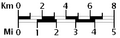
A graphical or bar scale. A map would also usually give its scale numerically ("1:50,000", for instance, means that one cm on the map represents 50,000cm of real space, which is 500 meters)
-
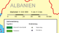
A bar scale with the nominal scale , expressed as both "1cm = 6km" and "1:600 000" (equivalent, because 6km = 600 000cm)

See also
 In Spanish: Escala (cartografía) para niños
