Sebec River facts for kids
Quick facts for kids Sebec River |
|
|---|---|

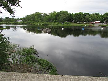
View of the Sebec River as seen from route 11 in Milo Maine.
|
|
| Country | United States |
| Physical characteristics | |
| Main source | Maine 300 feet (91 m) |
| River mouth | Piscataquis River 265 feet (81 m) 45°14′01″N 68°57′47″W / 45.2337°N 68.9630°W |
| Length | 10 miles (16 km) |
| Basin features | |
| Progression | Piscataquis River – Penobscot River |
The Sebec River is a fun river in Maine, USA. It's like a smaller stream that flows into a bigger river, the Piscataquis River. The Sebec River starts at Sebec Lake in a town called Sebec. From there, it travels about 10 miles (16 km) east and southeast. It finally joins the Piscataquis River in the town of Milo.
Sebec Lake: Where the River Begins
| Sebec Lake | |
|---|---|
| Lua error in Module:Location_map at line 420: attempt to index field 'wikibase' (a nil value). | |
| Location | Piscataquis County, Maine |
| Primary outflows | Sebec River |
| Max. length | 11.4 mi (18.3 km) |
| Surface area | 6,362 acres (2,575 ha) |
| Water volume | 283,337 acre⋅ft (349,491,000 m3) |
| Surface elevation | 322 ft (98 m) |
Sebec Lake is a large lake in Maine. It's where the Sebec River gets its start. The lake stretches out from the town of Sebec. It also touches parts of Dover-Foxcroft and other nearby areas.
Many smaller streams flow into Sebec Lake. On the south side, you'll find streams like Bog Brook and Cotton Brook. On the north side, there's Mill Brook and Grapevine Stream. The biggest streams flowing into the lake are Wilson Stream and Ship Pond Stream. These streams bring water from other ponds and areas into Sebec Lake.
Wilson Ponds: High Up in the Mountains
| Upper Wilson Pond | |
|---|---|
| Lua error in Module:Location_map at line 420: attempt to index field 'wikibase' (a nil value). | |
| Location | Piscataquis County |
| Primary outflows | Lower Wilson Pond |
| Max. length | 2.2 mi (3.5 km) |
| Surface area | 987 acres (399 ha) |
| Water volume | 13,053 acre⋅ft (16,101,000 m3) |
| Surface elevation | 1,123 ft (342 m) |
| Lower Wilson Pond | |
|---|---|
| Lua error in Module:Location_map at line 420: attempt to index field 'wikibase' (a nil value). | |
| Location | Piscataquis County |
| Primary inflows | Upper Wilson Pond |
| Primary outflows | Big Wilson Stream |
| Max. length | 2.8 mi (4.5 km) |
| Surface area | 1,414 acres (572 ha) |
| Water volume | 40,050 acre⋅ft (49,400,000 m3) |
| Surface elevation | 1,122 ft (342 m) |
Wilson Stream starts at a place called Upper Wilson Pond. This pond is high up in the mountains. Other small streams, like North Brook and South Brook, flow into Upper Wilson Pond. Water then flows from Upper Wilson Pond into Lower Wilson Pond.
From Lower Wilson Pond, Wilson Stream flows about 17 miles (27 km) south. It eventually reaches Sebec Lake. The famous Appalachian Trail crosses Wilson Stream. This trail is a long hiking path that goes through many states. Along the trail, you can see amazing sights like Big Wilson Cliffs and Little Wilson Falls and Gorge. These are beautiful spots to visit!
Lake Onawa: A Scenic Spot
| Lake Onawa | |
|---|---|
| Lua error in Module:Location_map at line 420: attempt to index field 'wikibase' (a nil value). | |
| Location | Piscataquis County |
| Primary inflows | Long Pond Stream |
| Primary outflows | Ship Pond Stream |
| Max. length | 3.4 mi (5.5 km) |
| Surface area | 1,192 acres (482 ha) |
| Water volume | 26,679 acre⋅ft (32,908,000 m3) |
| Surface elevation | 537 ft (164 m) |
Lake Onawa is also known as Ship Pond. It's located in a scenic area of Maine. A stream called Long Pond Stream flows into the north end of Lake Onawa. Then, water flows out of the south end of Lake Onawa into Ship Pond Stream. This stream then travels about 5 miles (8 km) south to Sebec Lake.
A long time ago, in 1887, a railroad called the International Railway of Maine was built along Lake Onawa. One of the highest bridges on this railroad was the Ship Pond Viaduct. This bridge was very long, over 1200 feet (370 meters), and it crossed 130 feet (40 meters) above Ship Pond Stream!
 | James B. Knighten |
 | Azellia White |
 | Willa Brown |

