Segovia, Antioquia facts for kids
Quick facts for kids
Segovia, Antioquia
|
|||
|---|---|---|---|
|
Municipality and town
|
|||
|
|||

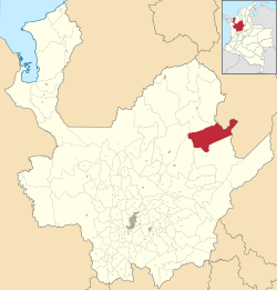
Location of the municipality and town of Segovia, Antioquia in the Antioquia Department of Colombia
|
|||
| Country | |||
| Department | |||
| Subregion | Northeastern | ||
| Area | |||
| • Municipality and town | 1,127 km2 (435 sq mi) | ||
| • Urban | 3.82 km2 (1.47 sq mi) | ||
| Elevation | 650 m (2,130 ft) | ||
| Population
(2018 census)
|
|||
| • Municipality and town | 37,900 | ||
| • Density | 33.63/km2 (87.10/sq mi) | ||
| • Urban | 30,133 | ||
| • Urban density | 7,888/km2 (20,430/sq mi) | ||
| Time zone | UTC-5 (Colombia Standard Time) | ||
Segovia is a town and a special area called a municipality in Antioquia Department, Colombia. It is located in the northeastern part of Antioquia. Segovia sits about 650 meters (2,130 feet) above sea level. This area is well-known for its gold mines.
Climate in Segovia
Segovia has a warm and humid climate. The weather here is usually quite steady throughout the year. This table shows you what the weather is typically like in Segovia. It includes information on temperature, rainfall, and sunshine.
| Climate data for Segovia (Otú Airport), elevation 718 m (2,356 ft), (1981–2010) | |||||||||||||
|---|---|---|---|---|---|---|---|---|---|---|---|---|---|
| Month | Jan | Feb | Mar | Apr | May | Jun | Jul | Aug | Sep | Oct | Nov | Dec | Year |
| Mean daily maximum °C (°F) | 28.6 (83.5) |
29.1 (84.4) |
28.9 (84.0) |
29.1 (84.4) |
29.2 (84.6) |
29.4 (84.9) |
29.6 (85.3) |
29.7 (85.5) |
29.0 (84.2) |
28.6 (83.5) |
28.2 (82.8) |
28.2 (82.8) |
29 (84) |
| Daily mean °C (°F) | 24.8 (76.6) |
25.0 (77.0) |
24.9 (76.8) |
25.0 (77.0) |
25.0 (77.0) |
25.1 (77.2) |
25.1 (77.2) |
25.2 (77.4) |
24.9 (76.8) |
24.8 (76.6) |
24.6 (76.3) |
24.7 (76.5) |
24.9 (76.8) |
| Mean daily minimum °C (°F) | 20.0 (68.0) |
20.2 (68.4) |
20.4 (68.7) |
20.4 (68.7) |
20.3 (68.5) |
20.1 (68.2) |
19.9 (67.8) |
20.0 (68.0) |
20.0 (68.0) |
20.0 (68.0) |
20.1 (68.2) |
20.0 (68.0) |
20.1 (68.2) |
| Average precipitation mm (inches) | 60.9 (2.40) |
77.0 (3.03) |
121.5 (4.78) |
281.1 (11.07) |
325.3 (12.81) |
280.3 (11.04) |
296.5 (11.67) |
336.2 (13.24) |
361.4 (14.23) |
368.0 (14.49) |
265.4 (10.45) |
132.7 (5.22) |
2,906.3 (114.42) |
| Average precipitation days (≥ 1.0 mm) | 9 | 10 | 11 | 18 | 19 | 18 | 18 | 20 | 20 | 21 | 18 | 12 | 190 |
| Average relative humidity (%) | 85 | 85 | 86 | 86 | 85 | 85 | 84 | 84 | 86 | 86 | 86 | 86 | 85 |
| Mean monthly sunshine hours | 173.6 | 144.0 | 120.9 | 114.0 | 136.4 | 156.0 | 195.3 | 179.8 | 144.0 | 133.3 | 138.0 | 161.2 | 1,796.5 |
| Mean daily sunshine hours | 5.6 | 5.1 | 3.9 | 3.8 | 4.4 | 5.2 | 6.3 | 5.8 | 4.8 | 4.3 | 4.6 | 5.2 | 4.9 |
| Source: Instituto de Hidrologia Meteorologia y Estudios Ambientales | |||||||||||||
See also
 In Spanish: Segovia (Antioquia) para niños
Black History Month on Kiddle
Renowned African-American Artists:
 | Kyle Baker |
 | Joseph Yoakum |
 | Laura Wheeler Waring |
 | Henry Ossawa Tanner |

All content from Kiddle encyclopedia articles (including the article images and facts) can be freely used under Attribution-ShareAlike license, unless stated otherwise. Cite this article:
Segovia, Antioquia Facts for Kids. Kiddle Encyclopedia.


