
Seven islands of Bombay facts for kids

The Seven Islands of Bombay were a group of small islands located very close to each other. Over many years, these islands were joined together to create the large city we know today as Mumbai in India. This amazing change helped Mumbai grow into one of the biggest and most important cities in the world.
Contents
How Mumbai Became One Big Island
Imagine seven separate pieces of land, surrounded by water, where a huge city now stands. That's exactly what Mumbai was like a long time ago! These islands were gradually connected to each other, mostly by filling in the shallow areas of the sea between them. This process is called land reclamation.
The Original Seven Islands
The seven islands that formed the core of modern Mumbai were:
- Bombay Island: This was the main island.
- Colaba: Located at the southern tip.
- Old Woman's Island: Also known as Little Colaba, it was very small.
- Mahim: An island to the north.
- Mazagaon: Another island, known for its hills.
- Parel: Located in the central part.
- Worli: An island on the western side.
These islands were separated by narrow channels of water. Traveling between them was often difficult, especially during high tides.
From Separate Islands to a City
The journey to connect these islands began centuries ago. The first major efforts to join them started in the 17th century. The goal was to make travel easier and to create more land for people to live and work.
Early Connections
One of the earliest projects was building a causeway (a raised road over water) between Bombay and Worli. This helped link the western parts of the islands. Over time, more causeways and embankments (walls to hold back water) were built.
The Hornby Vellard Project
A very important project was the Hornby Vellard, completed in 1784. This massive wall helped block the sea between Bombay and Worli. It allowed the low-lying areas to be drained and filled, creating new land. This was a huge step in joining the islands.
More Land Reclamation
Throughout the 19th and 20th centuries, more and more land was reclaimed. Swamps were drained, and the gaps between the islands were filled with earth and rocks. This created large, continuous areas of land. By the mid-20th century, the seven islands had largely merged into one big landmass.
Who Owned the Islands?
The islands had a long and interesting history of ownership:
- Portuguese Rule: In 1534, the Portuguese took control of the islands. They ruled them for over a century.
- British Rule: In 1661, the islands were given to the British as part of a marriage agreement. King Charles II of England received them as a gift when he married Catherine of Braganza, a Portuguese princess. The British then leased the islands to the East India Company in 1668. The East India Company was a powerful trading company that helped manage British interests in India.
Under British rule, the islands began to develop rapidly. The British saw the potential for a major port and trading center, which led to the large-scale land reclamation projects.
Mumbai Today
Today, Mumbai is a bustling metropolis, home to millions of people. It's a global center for finance, entertainment, and trade. The city's unique geography, built on the foundation of those original seven islands, has played a huge role in its growth and success. When you look at a map of Mumbai now, it's hard to imagine it was once a collection of small, separate islands!
Images for kids
-
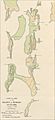
Island of Bombay and Colaba
-
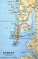
Map of Bombay in 1893.


See also
 In Spanish: Siete islas de Bombay para niños
