Shady Lane, Indiana facts for kids
Quick facts for kids
Shady Lane
|
|
|---|---|
| Country | United States |
| State | Indiana |
| County | Clay |
| Township | Brazil |
| Elevation | 653 ft (199 m) |
| GNIS feature ID | 443250 |
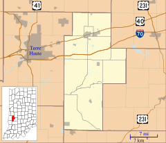
Shady Lane is a small place in Indiana, United States. It is known as an unincorporated community. This means it's a neighborhood or village that doesn't have its own local government, like a city or town does. Instead, it's part of a larger area called Brazil Township in Clay County.
Shady Lane is also close to a bigger city called Terre Haute. It is part of the Terre Haute Metropolitan Statistical Area. This means it's connected to the bigger city for things like jobs and services.
The name Shady Lane is pretty cool! It got its name because its streets were lined with lots of trees, making them nice and shady.
Where is Shady Lane?
Shady Lane is located in the state of Indiana, USA. You can find it at these coordinates: 39 degrees, 32 minutes, 44 seconds North (latitude) and 87 degrees, 8 minutes, 1 second West (longitude). These numbers help pinpoint its exact spot on a map. It sits about 653 feet (or 199 meters) above sea level.


