
Shirebourne brook facts for kids
.jpg)
The Shirebourne is a small stream, also known as a brook, that starts in a park called King George's Fields in Hadley. It flows for a while and then joins a larger stream called the Pymmes Brook. Long ago, this brook might have been an important marker for the old border between two counties, Hertfordshire and Middlesex.
Where to Find the Shirebourne
The Shirebourne brook begins its journey in King George's Fields in Hadley. For part of its path, it flows underground through a large pipe, which is called a culvert. This happens between the eastern side of King George's Fields and Bosworth Road.
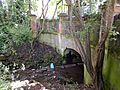
The brook then comes back above ground at the southwest corner of the Victoria Recreation Ground in New Barnet. From there, it flows along the southern edge of this park. It then goes under Park Road before finally meeting and joining the Pymmes Brook.
The Shirebourne's History
The name "Shirebourne" has a long history! It might have come from an Old English word, "Scirbrunan," which means "county stream." This name suggests that the brook was important for marking a boundary.
Records from the Barnet Manor Rolls in 1277 already mention the name Shirebourne. Later, in 1556, the upper parts of the Shirebourne, which are now in King George's Fields, were known as Sheredyche. Even more records, like the manor rolls from 1699, talk about a field called Sherborne Meadow. The 1817 enclosure map also shows Sherbourn Field right next to the Shirebourne. All these old names and maps suggest that the brook was a well-known landmark. It's believed that the Shirebourne was the stream that formed the historic boundary between the counties of Hertfordshire and Middlesex.
Images for kids
-

A bridge over the Shirebourne at Victoria Recreation Ground, looking south.
-
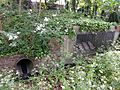
The spot where the Shirebourne brook comes out from its underground pipe at Victoria Recreation Ground.
-
The south bank of the Shirebourne brook at Victoria Recreation Ground.


