
Pymmes Brook facts for kids


Pymmes Brook is a small river in North London. It is named after William Pymme, who owned land nearby a long time ago. This brook is a minor tributary (a smaller river that flows into a larger one) of the River Lea. The brook mostly flows through towns and cities. Because of this, it can sometimes flood, especially in its lower parts. To help stop flooding, parts of the brook have been covered over in underground pipes called culverts. Some areas of Pymmes Brook are important for nature and are protected as a Site of Borough Importance for Nature Conservation, Grade II.
Contents
Where Does Pymmes Brook Start and End?
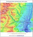
The Pymmes Brook begins from underground springs at Hadley Common. These springs were even mentioned in stories about the Battle of Barnet, a big fight during the Wars of the Roses. At first, this part of the brook is called Monken Mead Brook. It then flows southeast and eventually joins the River Lee Navigation in Tottenham.
Journey Through North London
The brook flows through several areas. It goes through East Barnet, where another small stream called the Shirebourne brook joins it. Then, it continues through New Southgate, Arnos Grove, Palmers Green, and Edmonton. After passing through Pymmes Park, you can see the brook at Fore Street in Edmonton. From there, it goes underground again. It comes back out south of the North Circular Road at Angel Road. Here, it meets Salmons Brook. The Pymmes Brook then flows next to the River Lee Navigation in Tottenham Marshes. Finally, it joins the River Lea near Ferry Lane A503 and Tottenham Lock.
Parks Along Pymmes Brook
You can see Pymmes Brook in several larger parks. These parks offer great places to visit and enjoy nature.
Major Parks to Explore
- Arnos Park
- Pymmes Park
- Oak Hill Park
- Brunswick Park
The brook also flows through many other smaller open spaces and green areas.
Walking Along the Pymmes Brook Trail
There is a special path called the Pymmes Brook Trail. This trail starts where the brook begins on Hadley Green. It follows the brook's path all the way to where it joins the River Lea at Tottenham Hale. From there, you can connect to the Lea Valley Walk, which is another long walking path.
A Look Back at Pymmes Brook's History
The name "Pymmes Brook" is shown on old maps, like the Ordnance Survey map from 1877. But the brook has had different names over time. Around the year 1200, it was called Medeseye. This name came from old English words meaning 'meadow marsh-stream'.
Later, during the Middle Ages, it was known as the Medesenge. In the late 1600s, people called it Millicents brook. By the late 1700s, it was known as Bell brook.
Water Quality in Pymmes Brook
Pymmes Brook gets most of its water from rain that runs off city streets. This water can carry pollution from roads and other urban areas. Sometimes, water from combined sewage pipes also overflows into the brook. There is also some overflow from Jacks (Beechhill) Lake.
Past Flooding and Reinforcement
In the 1930s, Jacks Lake flooded badly. This caused a lot of damage in East Barnet. Greenhouses and even cows were carried downstream by the floodwaters! After this event, the banks of the brook and the first part of its channel were made much stronger with concrete.
Current Water Health
The water quality in Pymmes Brook shows that there is a lot of pollution. For example, some pipes are wrongly connected, leading to very high levels of bacteria like Escherichia coli (E. coli). At a place called Cat Hill, the E. coli levels can often be over 1 million colonies per 100 milliliters of water.
Scientists also look at small water bugs (macroinvertebrates) to check water health. The scores for Pymmes Brook are very low. This means there isn't much clean water life compared to a very clean river like the River Mimram. The best part of Pymmes Brook, near where it starts, has never scored very high. The dirt at the bottom of the channel also has high levels of heavy metals like lead, zinc, copper, and cadmium.
Images for kids
-
Topographic map of the Pymmes Brook catchment area, north London

