Shockoe Hill African Burying Ground facts for kids
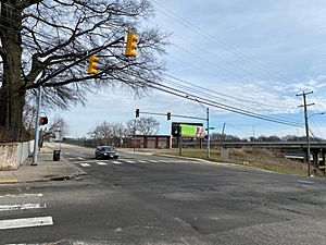
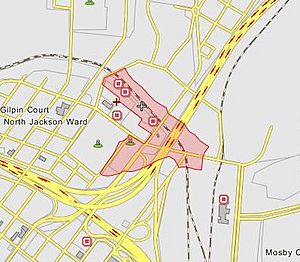
The Shockoe Hill African Burying Ground is a very important historical site in Richmond, Virginia. It was a burial place for both free African Americans and enslaved people. Today, you can't easily see it, but it's located near 5th and Hospital Street. This burying ground opened in 1816, replacing an older one in Shockoe Bottom. It is now considered one of Virginia's most endangered historical places.
Contents
History of the Burying Ground
How it Started
The Shockoe Hill African Burying Ground began in 1816. It was a separate section of the larger Shockoe Hill Cemetery, which was owned by the city of Richmond. A superintendent managed the burying ground, along with the city's Poorhouse (also called the Almshouse) and City Hospital.
The Richmond City Council also had a committee that watched over the burying ground. This burial ground was used from February 1816 until June 1879, when it became too full. Today, there's nothing on the surface to show it's a cemetery. It started with two one-acre plots at 5th and Hospital Street, next to the Hebrew Cemetery. Over time, it grew much larger, possibly covering up to 31 acres.
Names on Maps
Over the years, this important site was called different names on maps. In the 1870s, maps started calling it "Potter's Field." It last appeared on a map in 1905. That map showed it stretched west behind The Almshouse and north to Bacon's Quarter Branch. Some maps even showed it reaching almost to 8th Street.
Earlier maps used other names. In 1816, it was called "Burying Ground for Free People of Colour" and "Burying Ground for Negroes." By 1835, it was known as "Grave Yard for Free People of Colour" and "For Slaves." The area for enslaved people had grown by then. In 1849, it was simply called the "Burying-ground for Coloured Persons."
City Hospital Area
During the American Civil War, more than 500 Union Army prisoners of war were buried here. After the war, their bodies were moved to the Richmond National Cemetery. Most of these soldiers were buried near the City Hospital (which treated smallpox) and the Poorhouse.
The City Hospital building later became the Colored Almshouse in 1868. The city added the hospital grounds to the African Burying Ground in 1850. Even before that, in 1816, the northern part of the hospital grounds was used to bury poor people who died at the Poorhouse, both Black and white.
Damage to the Burying Ground
This historic burying ground has faced many challenges. For many years, it was a target for body snatching. This happened because medical schools, like the Medical College of Virginia and the University of Virginia, needed bodies for study.
The ground was also damaged by a gunpowder magazine explosion in 1865. Later, two new powder magazines were built on top of it in 1867. Over time, parts of the land were used for other things. Some became part of the Hebrew Cemetery. Roads, a railway, and a highway were built through it. Today, a gas station and a billboard sit on part of its original land. Other parts are under Interstate-64, 5th Street, and Hospital Street.
How Many People Are Buried Here?
Records show that over 22,000 people were buried in the Shockoe Hill African Burying Ground. This likely makes it the largest burial ground for free people of color and enslaved people in the United States. Today, some people call it the "2nd African Burial Ground" or "African Burial Ground II."
Recent Efforts to Protect It
Recently, people have worked hard to get support for the Shockoe Hill African Burying Ground. In 2020, Mayor Levar Stoney helped pass two important laws. One law added a property at 1305 N 5th Street to the Richmond Slave Trail. The other law helped the city buy this property. Both laws were approved by the Richmond City Council. This 1.2-acre property is a small but very important part of the original 1816 burying ground.
On May 11, 2021, Preservation Virginia named the Shockoe Hill African Burying Ground one of Virginia's Most Endangered Historic Places. On June 17, 2021, a proposal for a historical highway marker was approved.
On March 17, 2022, the Shockoe Hill Burying Ground Historic District was added to the Virginia Landmarks Register. This means it's officially recognized as a special historic place in Virginia.
On May 7, 2022, the National Park Service received a request to add the Shockoe Hill Burying Ground Historic District to the National Register of Historic Places.
On June 12, 2022, the new Historic Highway Marker for the Shockoe Hill African Burying Ground was revealed at 1305 N 5th Street.
Finally, on June 16, 2022, the Shockoe Hill Burying Ground Historic District was officially added to the National Register of Historic Places. This is a big step in protecting and remembering this important site.
 | Laphonza Butler |
 | Daisy Bates |
 | Elizabeth Piper Ensley |


