Sims, Indiana facts for kids
Quick facts for kids
Sims, Indiana
|
|
|---|---|

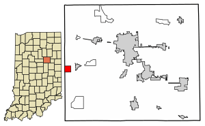
Location of Sims in Grant County, Indiana.
|
|
| Country | United States |
| State | Indiana |
| County | Grant |
| Township | Sims |
| Area | |
| • Total | 1.00 sq mi (2.58 km2) |
| • Land | 1.00 sq mi (2.58 km2) |
| • Water | 0.00 sq mi (0.00 km2) |
| Elevation | 860 ft (260 m) |
| Population
(2020)
|
|
| • Total | 164 |
| • Density | 164.33/sq mi (63.46/km2) |
| ZIP code |
46986
|
| FIPS code | 18-69894 |
| GNIS feature ID | 2583470 |
Sims is a small community in Grant County, Indiana. It is a census-designated place (CDP), which means it's an area the government counts for population. Sims is located within Sims Township. In 2010, about 156 people lived there. By 2020, the population grew slightly to 164 people.
History of Sims
The community of Sims got its name from Sims Township. This is the larger area it is part of.
A post office first opened in Sims in 1881. It served the community for many years. The post office eventually closed down in 1992.
Geography of Sims
Sims is located close to the western edge of Grant County. It is about 2 miles (3.2 kilometers) west of a town called Swayzee. Sims is also about 13 miles (21 kilometers) southwest of Marion. Marion is the main city in the county, known as the county seat.
A train track runs along the north side of Sims. This rail line is operated by the Central Railroad Company of Indianapolis.
The U.S. Census Bureau states that the Sims CDP covers a total area of about 1 square mile (2.6 square kilometers). All of this area is land, meaning there are no lakes or rivers within its borders.
Population and People
The population of Sims is counted by the U.S. Census Bureau. This count helps us know how many people live in an area.
| Historical population | |||
|---|---|---|---|
| Census | Pop. | %± | |
| 2020 | 164 | — | |
| U.S. Decennial Census | |||
In 2020, the population of Sims was 164 people. This shows how the number of residents has changed over time.
See also
 In Spanish: Sims (Indiana) para niños
 | Mary Eliza Mahoney |
 | Susie King Taylor |
 | Ida Gray |
 | Eliza Ann Grier |


