South Van Horn, Alaska facts for kids
Quick facts for kids
South Van Horn
|
|
|---|---|

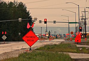
Van Horn Road westbound at South Cushman Street in June 2012. In the background is a portion of the business district which runs along the CDP's northern edge.
|
|
| Country | United States |
| State | Alaska |
| Borough | Fairbanks North Star Borough |
| Area | |
| • Total | 8.55 sq mi (22.15 km2) |
| • Land | 7.87 sq mi (20.37 km2) |
| • Water | 0.69 sq mi (1.77 km2) |
| Elevation | 418 ft (127.4 m) |
| Population
(2020)
|
|
| • Total | 503 |
| • Density | 63.95/sq mi (24.69/km2) |
| Time zone | UTC-9 (Alaska (AKST)) |
| • Summer (DST) | UTC-8 (AKDT) |
| FIPS code | 02-72230 |
South Van Horn is a special kind of community in Alaska, United States. It is called a census-designated place (CDP). This means it is an area identified by the government for counting people. It is not an officially incorporated city or town.
South Van Horn is located in the Fairbanks North Star Borough. In 2010, about 558 people lived there. By 2020, the population was 503. This community is near the Fairbanks International Airport.
Geography of South Van Horn
South Van Horn is located in Alaska at coordinates 64°48′34″N 147°47′17″W. The area is mostly land, with some water.
The total area of the CDP is about 8.52 square miles (22.15 square kilometers). Most of this, about 8.04 square miles (20.37 square kilometers), is land. The rest, about 0.48 square miles (1.77 square kilometers), is water.
The land in South Van Horn is about 418 feet (127.4 meters) above sea level.
People and Population
The population of South Van Horn has changed over time.
- In 2010, the population was 558 people.
- In 2020, the population was 503 people.
The average age of people living in South Van Horn is about 42.4 years old. Nearly half of the adults, 49.3%, are married. On average, each home has about 2.51 people living in it.
The median household income in South Van Horn is $39,883. This is the middle income for all households in the area. The unemployment rate is 5.5%.
See also
 In Spanish: South Van Horn (Alaska) para niños
 | Tommie Smith |
 | Simone Manuel |
 | Shani Davis |
 | Simone Biles |
 | Alice Coachman |

