Southwark St George the Martyr facts for kids
| Southwark St George the Martyr | |
 |
|
| Geography | |
| Status | Civil parish |
| 1881 area | 284 acres (1.15 km2) |
| HQ | Vestry Hall, Borough Road |
| History | |
| Origin | Ancient parish |
| Abolished | 1930 |
Quick facts for kids Demography |
|
|---|---|
| 1881 population - 1881 density |
58,652 206/acre |
| Politics | |
| Governance | Vestry of the Parish of Southwark St George the Martyr (1855—1900) |
Imagine a small local area in London that used to have its own government – that was Southwark St George the Martyr. It was a 'civil parish,' which is like a local district. It was part of the older area called the Borough of Southwark.
For a while, starting in 1855, it had its own local council, called a 'vestry,' which helped manage things in the area. Later, in 1900, it became part of a bigger London area called the Metropolitan Borough of Southwark. Finally, this old district stopped existing as a separate civil parish in 1930.
Contents
A Look at History
In 1295, the old area of Southwark gained the right to have its own representatives. This area first included several 'parishes' (like local church districts). These included St George the Martyr, along with St Margaret, St Mary, and St Olave.
Where Was It?
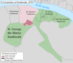
Most of the Southwark St George the Martyr area was around a place called St George's Circus. The streets Newington Causeway and Borough High Street formed its eastern edge. This part of the area was also known as St George's Fields.
The parish also had a long, narrow section that stretched along the Old Kent Road. This part ended near what is now Burgess Park. It even wrapped around the triangular-shaped parish of Newington on two sides. In 1881, the area covered about 284 acres (1.15 square kilometers) and had nearly 60,000 people living there.
How It Was Governed
From 1855, the local council (called a 'vestry') for Southwark St George the Martyr became a local authority. This meant it had power to make decisions for its area. It worked under the larger Metropolitan Board of Works, which managed big projects across London.
Local Wards and Councils
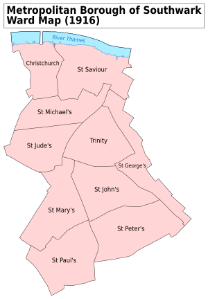
A law called the Metropolis Management Act 1855 said that any parish with more than 2,000 'ratepayers' (people who paid local taxes) had to be divided into smaller sections called wards. Because of this, the vestry of St George the Martyr was split into three wards:
- No. 1 or St Michael (which elected 18 council members)
- No. 2 or St Paul (which elected 15 council members)
- No. 3 or St George (which elected 15 council members)
In 1900, Southwark St George the Martyr became part of the Metropolitan Borough of Southwark. At this point, its old vestry council was replaced by the new Southwark Metropolitan Borough Council. The civil parish officially stopped existing in 1930.
Church Parishes
The original church parish, named after St George the Martyr, was part of different church areas over time. It was in the Diocese of Winchester until 1877, then the Diocese of Rochester until 1905, and finally the Diocese of Southwark. A 'diocese' is a large area managed by a bishop.
As more and more people moved into Southwark St George the Martyr, the population grew very quickly. Because of this, six smaller church parishes were created from 1843 onwards to serve the growing community:
- St Mary Magdalene, Southwark (created in 1843)
- St Jude, Southwark (created in 1850)
- St Stephen, Southwark (created in 1853)
- St Paul, Southwark (created in 1858)
- St Michael and All Angels, Southwark (created in 1867)
- St Alphege, Southwark (created in 1872)
 | Sharif Bey |
 | Hale Woodruff |
 | Richmond Barthé |
 | Purvis Young |


