
St. George's Bay (Nova Scotia) facts for kids

St. George's Bay is a large bay in the Canadian province of Nova Scotia. It is found on the northern coast of the province. This bay sits between the main Nova Scotia peninsula and Cape Breton Island. It is like a smaller part of the much larger Gulf of St. Lawrence.
Contents
About St. George's Bay
St. George's Bay is quite wide. At its opening, it measures about 25 kilometers (15 miles) across. This opening is between Cape George on the west and Black Point on the east.
The western side of the bay stretches for about 23 kilometers (14 miles). It goes from the tip of Cape George down to the entrance of Antigonish Harbour. The southern shore is longer, about 43 kilometers (27 miles). It runs from Antigonish Harbour to the Strait of Canso. The eastern shore is about 42 kilometers (26 miles) long. It goes from Heffernan Point north to Black Point.
A Busy Waterway
St. George's Bay is important for ships. It marks the northern end of the Strait of Canso. This strait is one of three ways for water to leave the Gulf of St. Lawrence. Many ships use this route because of the Canso Canal.
To keep ships safe, the Canadian Coast Guard helps guide them. They have a special service called "Canso Traffic." This service uses sea lanes, which are like underwater roads, shown on maps for ships.
Islands in the Bay
Many islands are found within St. George's Bay. They are spread out from the northeast to the south and then to the northwest.
- Port Hood Island
- Henry Island
- Inside Havre Boucher:
- Ile du Havre
- Crispos Island
- La Batture
- Inside Linwood Harbour:
- Big Island
- Little Island
- Inside Tracadie Harbour:
- Tracadie Big Island (a barrier island)
- Flat Island
- Isaacs Island
- Perros Island
- Grahams Island
- Myettes Island
- McCalls Island
- Petitpas Island
- Pomquet Island
- Inside Pomquet Harbour:
- Ile a Magotte
- Pomquet Harbour Island
- Inside Monks Head Harbour:
- Morrell Island
- Inside Antigonish Harbour:
- Captains Island
- Gooseberry Island
- Harris Island
- Black Island
- Long Island
- Sheep Island
- Fallis Island
- Reef Island
- Blueberry Island
Communities Along the Shore
Many towns and villages are located along the shores of St. George's Bay. They are listed here from the northwest, moving south, and then to the northeast.
- Antigonish County
- Cape George Point
- Ballantynes Cove
- Cape George
- Lakevale
- West Lakevale
- Cribbons Point
- Morristown
- MacIsaacs Point
- Antigonish Harbour
- Jimtown
- Mahoneys Beach
- Harbour Centre
- Lanark
- Antigonish Landing
- Antigonish
- Greenwold
- Williams Point
- South River
- South River Station
- Southside Antigonish Harbour
- Monks Head
- Pomquet
- Upper Pomquet
- Pomquet Station
- Summerside
- Bayfield
- Afton
- Tracadie
- McCalls Island
- Big Tracadie
- Monastery
- East Tracadie
- West Linwood
- Linwood
- Cape Jack
- Havre Boucher
- East Havre Boucher
- Inverness County
- Troy
- Low Point
- Creignish
- Craigmore
- Long Point
- Judique South
- Judique
- Judique North
- Judique Intervale
- Little Judique
- Maryville
- Little Judique Ponds
- Harbourview
- Port Hood
- Marble Hill
- Port Hood Island
Images for kids
-
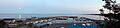
St. George's Bay as seen from the marina at Ballantynes Cove
