St. Peter, Kansas facts for kids
Quick facts for kids
St. Peter, Kansas
|
|
|---|---|

|
|
| Country | United States |
| State | Kansas |
| County | Graham |
| Elevation | 2,494 ft (760 m) |
| Time zone | UTC-6 (CST) |
| • Summer (DST) | UTC-5 (CDT) |
| Area code | 785 |
| FIPS code | 20-62525 |
| GNIS ID | 471325 |
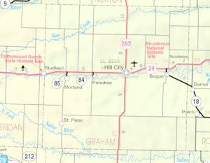
St. Peter is a small, quiet place in Kansas, United States. It's known as an "unincorporated community." This means it's a group of homes and buildings that isn't officially a town or city with its own local government. Instead, it's part of a larger area called Graham County.
A Look Back: The History of St. Peter
St. Peter wasn't always called St. Peter! Long ago, this community had a different name: Hoganville. Imagine a time when letters were sent by post office. Hoganville had its own post office, which opened in 1894. But after a while, in 1920, the post office closed down. Back in 1910, about 50 people lived in Hoganville.
Learning in St. Peter
Kids who live in St. Peter go to public schools. These schools are managed by the Graham County USD 281 school district. This district makes sure that students in the area have schools to attend and teachers to learn from.
 | Georgia Louise Harris Brown |
 | Julian Abele |
 | Norma Merrick Sklarek |
 | William Sidney Pittman |


