Starve Island facts for kids
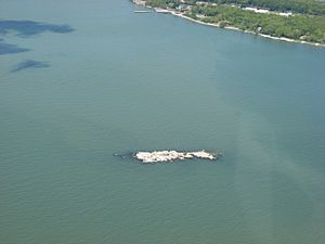
Starve Island is a small island located in Lake Erie, within the U.S. state of Ohio. It is about 2 acres (0.81 hectares) in size, which is roughly the size of two football fields. This island sits about a mile (1.6 km) south of South Bass Island. On a clear day, you can see it from a mile or two away. It often looks like just a few rocks and bushes sticking out of the water. Starve Island is the second smallest island in Lake Erie; the smallest is Turtle Island. You can even spot Starve Island from the top of the Perry's Victory and International Peace Memorial in Put-in-Bay.
Contents
What is Starve Island?
Starve Island is a tiny piece of land in the middle of Lake Erie. It's known for its small size and its interesting history. Despite its name, it's a natural part of the Lake Erie islands, which are popular spots for visitors.
Where is Starve Island Located?
Starve Island is found in Put-in-Bay Township, Ottawa County, Ohio. It's part of a group of islands in Lake Erie. Its location near South Bass Island makes it a neighbor to a much larger and more famous island.
How Did Starve Island Get Its Name?
The island's name, "Starve Island," comes from an old story. People say that a sailor once got shipwrecked there and sadly starved. This sad tale is how the island got its unique name. Other names for the island include Dinner Island and Glacial Island.
What About Starve Island Reef?
Just about a mile further south of Starve Island, you'll find the Starve Island Reef. A reef is an underwater ridge or a collection of rocks that can be dangerous for boats. The Starve Island Reef is located at 41°36′46″N 82°48′56″W. Both the island and the reef are part of the same area in Put-in-Bay Township.
 | Isaac Myers |
 | D. Hamilton Jackson |
 | A. Philip Randolph |


