
Strathaird, New South Wales facts for kids
Quick facts for kids StrathairdNew South Wales |
|
|---|---|

Strathaird
Location in New South Wales
|
|
| Population | 210 (2011 census) |
| Postcode(s) | 2580 |
| LGA(s) | Upper Lachlan Shire |
| State electorate(s) | Goulburn |
| Federal Division(s) | Hume |
Strathaird is a small area located in the Southern Tablelands of New South Wales, Australia. It is part of the Upper Lachlan Shire. You can find Strathaird about 6.8 kilometres south of the town of Taralga, right on the road to Goulburn.
This area was once a stop on the Taralga railway line. Even though the trains no longer run, the old station building is still there today.
Contents
Exploring Strathaird's Past
Early Inhabitants: The Burra Burra People
Long ago, the land around Strathaird was the home of the Burra Burra people. They were a group from the larger Gandangara Nation. The Burra Burra people lived off the land and had their own traditions and ways of life.
Their last big gathering, called a corroboree, happened in the 1830s. After this time, there are no more records of them by European historians. It is thought that the arrival of Europeans pushed them further west to new areas.
European Settlement and Wool Farming
In 1819, an explorer named Charles Throsby travelled through this region. He was looking for new places for animals to graze. Just a few years later, by 1824, members of the Macarthur family, James and his nephew Hannibal, settled in the Taralga area.
They were pioneers in Australia's wool industry. James Macarthur even gave land to create a small private village. This village was built by convicts and served the Macarthur family and their workers. Orchard Street, which is now the main street in Taralga, is located where Macarthur's fruit orchard used to be.
The Taralga Railway Line
The railway line that went through Strathaird and connected to Taralga opened in 1926. This line helped transport goods and people. However, it did not operate for very long, closing down in 1957.
Images for kids
-
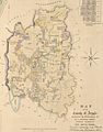
This map from the 1840s shows the County of Argyle.
-
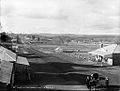
A picture of Taralga around the year 1900.

.jpg)
