Summersville, Kentucky facts for kids
Quick facts for kids
Summersville, Kentucky
|
|
|---|---|

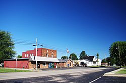
Businesses along KY 61
|
|
| Country | United States |
| State | Kentucky |
| County | Green |
| Area | |
| • Total | 2.89 sq mi (7.49 km2) |
| • Land | 2.89 sq mi (7.48 km2) |
| • Water | 0.00 sq mi (0.01 km2) |
| Elevation | 804 ft (245 m) |
| Population
(2020)
|
|
| • Total | 551 |
| • Density | 190.66/sq mi (73.62/km2) |
| Time zone | UTC-6 (Central (CST)) |
| • Summer (DST) | UTC-5 (CDT) |
| ZIP code |
42782
|
| FIPS code | 21-74604 |
| GNIS feature ID | 504784 |
Summersville is a small community in Green County, Kentucky, United States. It's known as a "census-designated place" (CDP). This means it's a special area that the government counts for population, but it doesn't have its own city government.
In 2010, about 568 people lived in Summersville. By 2020, the population was 551.
Summersville is located along two main roads, Route 61 and Route 323. It's about 6 miles (10 km) northwest of Greensburg, which is the main town of Green County. Summersville is 804 feet (245 meters) above sea level. It has its own post office with the ZIP code 42782.
Contents
History of Summersville
Summersville became an official community in 1817. This means it was formally recognized as a place where people lived and worked together.
Community Life in Summersville
Every year in late July, the people of Summersville celebrate with a special event called "Summersville Days." This festival brings the community together for fun and activities.
Population Information
The United States government counts how many people live in different areas every ten years. This is called a census.
Summersville Population Changes
Here's how the population of Summersville has changed over time:
| Historical population | |||
|---|---|---|---|
| Census | Pop. | %± | |
| 2020 | 551 | — | |
| U.S. Decennial Census | |||
See also
 In Spanish: Summersville (Kentucky) para niños
 | Selma Burke |
 | Pauline Powell Burns |
 | Frederick J. Brown |
 | Robert Blackburn |


