
Sunny Corner, New South Wales facts for kids
Quick facts for kids Sunny CornerNew South Wales |
|||||||||
|---|---|---|---|---|---|---|---|---|---|

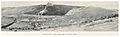
An old stamp mill at Sunny Corner
|
|||||||||

Sunny Corner
Location in New South Wales
|
|||||||||
| Population | 92 (2016 census) | ||||||||
| Elevation | 1,225 m (4,019 ft) | ||||||||
|
|||||||||
Sunny Corner is a small village in the central west of New South Wales, Australia. It's an old mining area found between the towns of Lithgow and Bathurst. You can find it just north of the main road, the Great Western Highway.
In 2016, only 92 people lived in Sunny Corner. That's a big change from 2006, when 626 people lived there!
The village wasn't always called Sunny Corner. It got its official name in 1885. Before that, people often called it "Mitchell" or "Mitchell's Creek." However, the people living there really liked the name Sunny Corner, so it stuck!
Contents
History of Sunny Corner
Who Lived Here First?
The first people to live in the area of Sunny Corner were likely the Wiradjuri people. Even though there were no Aboriginal people living there when written records began, old stone tools show they were once in this area.
How Sunny Corner Started
The town of Sunny Corner grew quickly after silver was found in 1884. This discovery caused a "rush" of people to the area. Before this, no one lived there. Soon, a town appeared on government land next to the new silver mines.
The village of Sunny Corner became official on October 2, 1885. At that time, the government also set aside land nearby for recreation and camping.
Life in the Early Town
In January 1886, a newspaper said that Sunny Corner had between 1,600 and 3,000 people! The town had one long, mostly straight street. Houses were built all over the hills and valleys. Most buildings had metal roofs, but their walls were made from wood or mud.
The town had many interesting places, like the Royal, Criterion, and Star Hotels. There was also the Carrington billiard room, the Sunny Corner Boot Palace, and the Tattersall's saddler's store.
Later, on September 3, 1887, Sunny Corner was officially called a town. Like many towns back then, it had a School of Arts. In the late 1890s, the town even had a very good choir that sang classical music.
Climate and Weather
Sunny Corner is high up on the dividing mountain range, over 1,200 meters (about 3,900 feet) above sea level. This means it gets weather from both the west and the east.
It often snows in winter and spring. Sometimes, it even snows as late as November! The area also gets strong thunderstorms and thick fog throughout the year.
| Climate data for Sunny Corner (Snow Line, 1907–1918, rainfall 1903–2008); 1,225 m AMSL; 33.39° S, 149.90° E | |||||||||||||
|---|---|---|---|---|---|---|---|---|---|---|---|---|---|
| Month | Jan | Feb | Mar | Apr | May | Jun | Jul | Aug | Sep | Oct | Nov | Dec | Year |
| Mean daily maximum °C (°F) | 25.2 (77.4) |
23.8 (74.8) |
21.1 (70.0) |
17.3 (63.1) |
12.3 (54.1) |
8.4 (47.1) |
7.1 (44.8) |
9.0 (48.2) |
13.5 (56.3) |
17.8 (64.0) |
21.2 (70.2) |
24.2 (75.6) |
16.7 (62.1) |
| Mean daily minimum °C (°F) | 10.4 (50.7) |
9.9 (49.8) |
8.1 (46.6) |
4.5 (40.1) |
1.6 (34.9) |
0.1 (32.2) |
−0.2 (31.6) |
0.3 (32.5) |
1.8 (35.2) |
3.1 (37.6) |
5.7 (42.3) |
8.3 (46.9) |
4.5 (40.0) |
| Average precipitation mm (inches) | 91.5 (3.60) |
76.9 (3.03) |
67.6 (2.66) |
61.8 (2.43) |
67.1 (2.64) |
79.2 (3.12) |
81.9 (3.22) |
80.8 (3.18) |
71.9 (2.83) |
88.6 (3.49) |
77.0 (3.03) |
77.7 (3.06) |
931.6 (36.68) |
| Average precipitation days (≥ 0.2 mm) | 8.0 | 8.0 | 7.4 | 7.4 | 8.8 | 10.6 | 10.4 | 9.7 | 8.8 | 9.2 | 8.4 | 7.8 | 104.5 |
| Source: Australian Bureau of Meteorology; Sunny Corner (Snow Line) | |||||||||||||
Mining History
Early Gold Discoveries
It's a bit tricky to know exactly when mining started in Sunny Corner. This is because it was a small area, and records weren't kept very well in the 1850s. Also, there was another "Mitchell's Creek" near a town called Wellington, which makes things confusing.
However, in 1852, a newspaper reported that gold was found in a quartz reef at Mitchells Creek. This was likely in the Sunny Corner area. By 1884, people said that gold was first found around Mitchell's Creek in 1852. Two years later, people were digging for gold in the rivers and streams, and they found a lot! In 1856, gold was also found in quartz rock.
From Gold to Silver
People mined the quartz rocks from the early 1860s until the 1880s. In 1881, tests showed that the rocks also had a lot of silver. So, miners started looking for silver instead of gold.
However, by 1897, the price of silver dropped very low. Because of this, the mine had to close down.
What Was Mined?
Between 1875 and 1922, miners dug up silver, gold, zinc, and antimony. During this time, they found more than 100 tonnes of silver!
Even though the mine closed over 100 years ago, the Sunny Corner mine area still has some environmental concerns. The water in the area contains higher levels of certain elements like arsenic, cadmium, copper, nickel, lead, and zinc.
Images for kids
-
Sunny Corner Smelter Works 1899
-
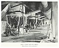
Sunny Corner Smelter Works 1899
-
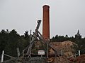
Abandoned mine site at Sunny Corner in 2011
_p237_SUNNY_CORNER_SMELTING_WORKS.jpg)

