Taminango facts for kids
Quick facts for kids
Taminango
|
|||
|---|---|---|---|
|
Municipality and town
|
|||
|
|||

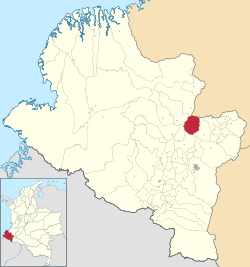
Location of the municipality and town of Taminango in the Nariño Department of Colombia.
|
|||
| Country | |||
| Department | Nariño Department | ||
| Founded | 1704 | ||
| Area | |||
| • Total | 284 km2 (110 sq mi) | ||
| Elevation | 1,465 m (4,806 ft) | ||
| Population
(2015)
|
|||
| • Total | 20,537 | ||
| • Density | 72.31/km2 (187.3/sq mi) | ||
| Time zone | UTC-5 (Colombia Standard Time) | ||
Taminango is a cool town and a special area called a municipality in the Nariño Department of Colombia. It's located in a beautiful part of the country. This place has a long history, as it was first settled way back in 1704. Imagine how much has changed since then!
In 2015, about 20,537 people called Taminango home. This means it's a lively community with many families and friends living and working together. The town is known for its friendly people and its connection to nature.
What's the Weather Like in Taminango?
Taminango has a climate that's pretty stable throughout the year. It's not too hot and not too cold, which makes it a comfortable place to live. The average temperature stays around 17 to 18 degrees Celsius (about 63 to 64 degrees Fahrenheit).
Rain and Sunshine
You'll find that Taminango gets a good amount of rain, especially from March to May and again from October to November. These are the wettest months, with lots of precipitation. The driest months are usually July and August, when there's less rain and more sunshine.
Humidity Levels
The air in Taminango can feel quite humid, especially during the rainy seasons. Humidity levels are highest from November to January, making the air feel moist. In contrast, July and August are the least humid months. This mix of rain and humidity helps the local plants and crops grow well.
| Climate data for Taminango, elevation 1,875 m (6,152 ft), (1981–2010) | |||||||||||||
|---|---|---|---|---|---|---|---|---|---|---|---|---|---|
| Month | Jan | Feb | Mar | Apr | May | Jun | Jul | Aug | Sep | Oct | Nov | Dec | Year |
| Mean daily maximum °C (°F) | 22.3 (72.1) |
22.7 (72.9) |
22.9 (73.2) |
22.8 (73.0) |
22.8 (73.0) |
23.2 (73.8) |
24.0 (75.2) |
24.8 (76.6) |
24.4 (75.9) |
23.0 (73.4) |
21.6 (70.9) |
21.6 (70.9) |
23.0 (73.4) |
| Daily mean °C (°F) | 17.3 (63.1) |
17.5 (63.5) |
17.7 (63.9) |
17.7 (63.9) |
17.9 (64.2) |
18.1 (64.6) |
18.4 (65.1) |
18.8 (65.8) |
18.1 (64.6) |
17.5 (63.5) |
17.1 (62.8) |
17.1 (62.8) |
17.8 (64.0) |
| Mean daily minimum °C (°F) | 14.3 (57.7) |
14.4 (57.9) |
14.6 (58.3) |
14.6 (58.3) |
14.7 (58.5) |
14.6 (58.3) |
14.4 (57.9) |
14.5 (58.1) |
14.1 (57.4) |
14.2 (57.6) |
14.3 (57.7) |
14.3 (57.7) |
14.4 (57.9) |
| Average precipitation mm (inches) | 138.2 (5.44) |
126.6 (4.98) |
167.1 (6.58) |
210.8 (8.30) |
168.1 (6.62) |
77.9 (3.07) |
55.8 (2.20) |
43.0 (1.69) |
92.9 (3.66) |
217.6 (8.57) |
237.4 (9.35) |
180.2 (7.09) |
1,715.6 (67.54) |
| Average precipitation days | 17 | 14 | 17 | 18 | 17 | 11 | 8 | 6 | 10 | 18 | 21 | 19 | 176 |
| Average relative humidity (%) | 89 | 88 | 88 | 89 | 87 | 82 | 74 | 70 | 79 | 87 | 90 | 90 | 85 |
| Source: Instituto de Hidrologia Meteorologia y Estudios Ambientales | |||||||||||||
See also
 In Spanish: Taminango para niños
 | Leon Lynch |
 | Milton P. Webster |
 | Ferdinand Smith |


