Tat Momoli, Arizona facts for kids
Quick facts for kids
Tat Momoli, Arizona
|
|
|---|---|

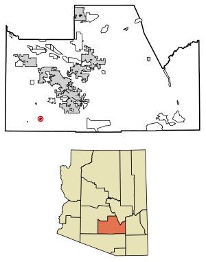
Location of Tat Momoli in Pinal County, Arizona.
|
|
| Country | United States |
| State | Arizona |
| County | Pinal |
| Area | |
| • Total | 0.93 sq mi (2.41 km2) |
| • Land | 0.93 sq mi (2.41 km2) |
| • Water | 0.00 sq mi (0.00 km2) |
| Population
(2020)
|
|
| • Total | 18 |
| • Density | 19.38/sq mi (7.48/km2) |
| Time zone | UTC-7 (MST (no DST)) |
| FIPS code | 04-72280 |
Tat Momoli (which is Taḍ Memelkuḍ in the Oʼodham language) is a small community in Pinal County, Arizona, in the United States. It is located on the Tohono Oʼodham Indian Reservation.
In 2010, only 10 people lived in Tat Momoli. By 2020, the population had grown to 18 people.
Where is Tat Momoli Located?
Tat Momoli is found in the state of Arizona. It is part of Pinal County. The community covers a total area of about 2.41 square kilometers (which is about 0.93 square miles). All of this area is land.
Who Lives in Tat Momoli?
| Historical population | |||
|---|---|---|---|
| Census | Pop. | %± | |
| 2020 | 18 | — | |
| U.S. Decennial Census | |||
In 2010, there were 10 people living in Tat Momoli. This meant there were about 4 people living in each square kilometer.
Most of the people living there were American Indians or Alaska Natives. Some residents were white, and others were from other races. About 30% of the people were of Hispanic or Latino background.
See also
 In Spanish: Tat Momoli para niños
 | James Van Der Zee |
 | Alma Thomas |
 | Ellis Wilson |
 | Margaret Taylor-Burroughs |

