Tatakoto facts for kids
Quick facts for kids
Tatakoto
|
|
|---|---|

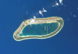
NASA picture of Tatakoto Atoll
|
|
 |
|
| Country | France |
| Overseas collectivity | French Polynesia |
| Subdivision | Îles Tuamotu-Gambier |
| Area
1
|
7.3 km2 (2.8 sq mi) |
| Population
(2017)
|
259 |
| • Density | 35.48/km2 (91.9/sq mi) |
| Time zone | UTC−10:00 |
| INSEE/Postal code |
98751 /98783
|
| 1 French Land Register data, which excludes lakes, ponds, glaciers > 1 km2 (0.386 sq mi or 247 acres) and river estuaries. | |
Tatakoto is a beautiful atoll in French Polynesia. It is part of the Tuamotu island group. An atoll is a ring-shaped island made of coral. It usually has a lagoon in the middle.
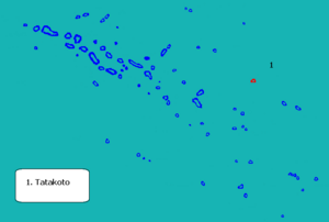
Tatakoto is quite far away from other islands. It is located in the eastern part of the Tuamotu chain. The atoll is about 1,182 kilometres (734 miles) from Tahiti. It stretches about 14 kilometres (9 miles) long and 3.5 kilometres (2 miles) wide.
The atoll has one main island and 65 smaller islets. These islets are separated by many channels. They form a ring around a calm lagoon. Most of these small islands are on the southern side. All the islands are flat. They are not much higher than the ocean. The land area of Tatakoto is about 7.3 square kilometers. Its central lagoon covers about 20 square kilometers.
The main village on Tatakoto is called Tumukuru. In 2017, the total population of the atoll was 259 people.
Contents
Discovering Tatakoto: A Brief History
Tatakoto Atoll was first seen by Europeans on the same day. This happened on October 29, 1774. Two Spanish captains, Domingo de Bonechea and José Andía y Varela, were on separate ships. They both landed on Tatakoto without knowing the other was there. They named the island "San Narciso" after a saint. The island was also known as "d'Augier" in the past.
José Andía wrote about the atoll. He said it looked "extremely agreeable to the eyes." He noted it was "very populated by shrubs." In the early 1900s, France took control of the island. They planted many coconut palm trees. These trees still cover much of the island today.
How Tatakoto is Governed
Tatakoto Atoll has its own local government. This is called a commune. A commune is like a small town or district. It helps manage local services. The Tatakoto commune is part of the Îles Tuamotu-Gambier administrative area. This area is a larger part of French Polynesia.
Getting to Tatakoto: Transport
The atoll has its own airport. It is called Tatakoto Airport. The airport code is TKV or NTGO. It helps people travel to and from the atoll. The airport was opened in 1979.
See also
 In Spanish: Tatakoto (atolón) para niños
 | Jackie Robinson |
 | Jack Johnson |
 | Althea Gibson |
 | Arthur Ashe |
 | Muhammad Ali |

