
Temburong District facts for kids
Quick facts for kids
Temburong
|
|
|---|---|
|
District
|
|
 |
|
| Capital | Bangar |
| Area | |
| • Total | 1,306 km2 (504 sq mi) |
| Population
(2016)
|
|
| • Total | 10,543 |
| • Density | 8.073/km2 (20.908/sq mi) |
| Website | http://temburong.gov.bn |
Temburong District is a special area in Brunei. It is like a separate piece of land. The main town and capital of Temburong is Bangar.
Temburong is an exclave. This means it is not directly connected to the rest of Brunei. Instead, Malaysia and Brunei Bay separate it. The Temburong River flows through the district. The Sungai Pandaruan river forms its western edge. Temburong is also home to Brunei's first national park. This park is called Ulu Temburong National Park. It is located in the southern part of the district.
Contents
Welcome to Temburong District!
Temburong District is one of the four districts in Brunei. It is known for its beautiful natural environment. The district covers a large area of 1,306 square kilometers. In 2016, about 10,543 people lived here.
Where is Temburong?
Temburong is unique because it is an "exclave." Imagine a piece of a country that is not connected to the main part. That's what Temburong is like! You have to travel through Malaysia or cross Brunei Bay to reach it from the rest of Brunei.
Two important rivers flow in and around Temburong. The Temburong River runs through the district. The Sungai Pandaruan river marks the western border. These rivers are very important for the local wildlife and people.
Exploring Temburong's Nature
One of the most exciting places in Temburong is the Ulu Temburong National Park. This was Brunei's very first national park. It is located in the southern part of the district. The park protects a huge area of untouched rainforest. It is a fantastic place to see amazing plants and animals. Many people visit to experience its natural beauty.
How Temburong is Organized
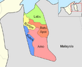
Temburong District is divided into five smaller areas. These areas are called mukims. Think of them as subdistricts or smaller regions within Temburong. Each mukim has its own communities and features.
The five mukims are:
- Amo
- Bangar
- Batu Apoi
- Bokok
- Labu
Images for kids
-
Mukims of Temburong district

See also
 In Spanish: Distrito de Temburong para niños
