Tererro, New Mexico facts for kids
Quick facts for kids
Tererro
|
|
|---|---|
| Country | United States |
| State | New Mexico |
| County | San Miguel |
| Elevation | 7,714 ft (2,351 m) |
| Time zone | UTC-7 (Mountain (MST)) |
| • Summer (DST) | UTC-6 (MDT) |
| ZIP codes |
87573
|
| Area code(s) | 505 |
| GNIS feature ID | 911611 |
Tererro is a small place in New Mexico, United States. It is not a city or a town with its own local government. Instead, it is known as an unincorporated community. This means it is part of a larger area, San Miguel County, which helps manage things there.
Exploring Tererro: A New Mexico Community
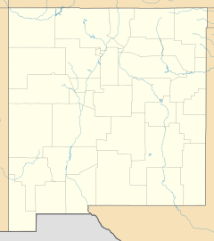
Tererro is a quiet community located in the beautiful state of New Mexico. It sits in San Miguel County, which is in the northeastern part of the state. Being an unincorporated community means that the county government, rather than a separate city government, provides services like roads and law enforcement.
Where is Tererro Located?
Tererro is found about 11.6 miles (or about 18.7 kilometers) north of a town called Pecos. It is situated right along New Mexico State Road 63. This road is important for connecting Tererro to other places in the area. The community is nestled in a scenic part of New Mexico, known for its natural beauty.
What is a ZIP Code?
Even though Tererro is a small community, it has its own post office and a special number called a ZIP code. The ZIP code for Tererro is 87573. A ZIP code is a series of numbers used by the United States Post Office to help sort mail and deliver it to the correct location. It makes sure that letters and packages sent to Tererro arrive exactly where they need to go.
 | Bessie Coleman |
 | Spann Watson |
 | Jill E. Brown |
 | Sherman W. White |


