
Tete Province facts for kids
Quick facts for kids
Tete
|
|
|---|---|
 |
|

Tete, Province of Mozambique
|
|
| Country | Mozambique |
| Capital | Tete |
| Area | |
| • Total | 98,417 km2 (37,999 sq mi) |
| Population
(2017 census)
|
|
| • Total | 2,648,941 |
| • Density | 26.91548/km2 (69.7108/sq mi) |
| Postal code |
23xx
|
| Area code(s) | (+258) 252 |
Tete is a province in the country of Mozambique. Mozambique is located in southeastern Africa. The main city of the province is also called Tete. This city is the capital of the Tete province.
Tete province is an important area. It has the large Zambezi River flowing through it. The famous Cahora Bassa Dam is also located in this province. This dam helps produce electricity for the region.
Areas of Tete Province
Tete province is divided into several smaller areas called districts. These districts help manage the different parts of the province.
Here are the districts in Tete Province:
- Angónia District
- Cahora-Bassa District
- Changara District
- Chifunde District
- Chiuta District
- Tete, which is the capital city of the province
- Doa District
- Macanga District
- Magoé District
- Marávia District
- Marara District
- Moatize District
- Mutarara District
- Tsangano District
- Zumbo District
Images for kids
-
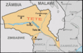
Provincial map of Tete
-
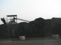
Moatize Coal Mine in Tete Province
-
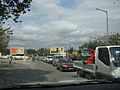
People waiting to cross the Tete Suspension Bridge
-
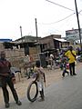
A view of Tete city


See also
 In Spanish: Provincia de Tete para niños

All content from Kiddle encyclopedia articles (including the article images and facts) can be freely used under Attribution-ShareAlike license, unless stated otherwise. Cite this article:
Tete Province Facts for Kids. Kiddle Encyclopedia.