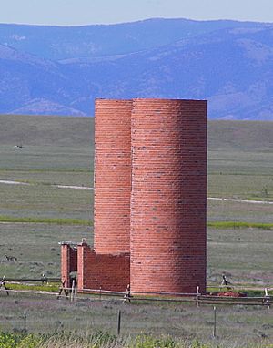
The Silos, Montana facts for kids
Quick facts for kids
The Silos, Montana
|
|
|---|---|

The Silos
|
|
| Country | United States |
| State | Montana |
| County | Broadwater |
| Area | |
| • Total | 5.13 sq mi (13.29 km2) |
| • Land | 5.13 sq mi (13.29 km2) |
| • Water | 0.00 sq mi (0.00 km2) |
| Elevation | 3,888 ft (1,185 m) |
| Population
(2020)
|
|
| • Total | 691 |
| • Density | 134.70/sq mi (52.01/km2) |
| Time zone | UTC-7 (Mountain (MST)) |
| • Summer (DST) | UTC-6 (MDT) |
| Area code(s) | 406 |
| FIPS code | 30-73760 |
| GNIS feature ID | 2583858 |
The Silos is a small community in Montana, United States. It's known as a "census-designated place" (CDP). This means it's an area identified by the U.S. Census Bureau for statistical purposes. In 2010, about 506 people lived there. By 2020, the population grew to 691. The Silos is located in Broadwater County, right next to a big lake called Canyon Ferry Lake.
Contents
Exploring The Silos' Location
The Silos is found on the western side of Canyon Ferry Lake. This lake is actually a large reservoir, which is a human-made lake, on the Missouri River.
How to Get Around The Silos
Major roads, U.S. 12 and U.S. 287, pass right through The Silos. These roads connect the community to other important places. For example, you can travel about 5 miles (8 km) southeast to Townsend, which is the main town in Broadwater County. If you head about 28 miles (45 km) northwest, you'll reach Helena, the capital city of Montana.
Land Area of The Silos
According to the United States Census Bureau, the total area of The Silos is about 5.13 square miles (13.3 square kilometers). All of this area is land, meaning there are no lakes or rivers within its official boundaries.
Understanding The Silos' Population
| Historical population | |||
|---|---|---|---|
| Census | Pop. | %± | |
| 2020 | 691 | — | |
| U.S. Decennial Census | |||
The population of The Silos has changed over time. In 2010, the census counted 506 people living there. By the 2020 census, the population had increased to 691 residents. This shows that more people are choosing to live in this area.
See also
 In Spanish: The Silos (Montana) para niños
 | Sharif Bey |
 | Hale Woodruff |
 | Richmond Barthé |
 | Purvis Young |


