Tinguipaya Municipality facts for kids
Quick facts for kids
Tinguipaya Municipality
|
|
|---|---|
|
Municipality
|
|

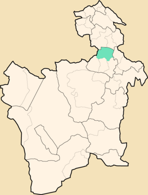
Location within Potosí Department
|
|
| Country | |
| Department | Potosí Department |
| Province | Tomás Frías Province |
| Seat | Tinguipaya |
| Population
(2001)
|
|
| • Total | 21,794 |
| • Ethnicities | Quechua |
| Time zone | UTC-4 (BOT) |
Tinguipaya Municipality is a part of the Tomás Frías Province in the Potosí Department in Bolivia. It is the first municipal section of the province. The main town and administrative center of the municipality is Tinguipaya.
Parts of Tinguipaya
The municipality is divided into different areas called cantons. These cantons help organize the local government and services.
- Anthura: This canton was created on November 9, 1992.
- Tinguipaya: This canton was created earlier, on December 29, 1949.
Mountains and Landscape
Tinguipaya Municipality is located in a special area between mountain ranges. The land here has many different heights. It ranges from about 3,100 meters (10,170 feet) to 4,882 meters (16,017 feet) above sea level.
The highest point in the municipality is a mountain called Malmisa. It stands tall at 4,882 meters. Many other impressive mountains are also found here. Some of them include:
|
|
|
People of Tinguipaya
Most of the people living in Tinguipaya Municipality are indigenous. The largest group is the Quechua. They have a rich history and culture in this region.
Here's a look at the different ethnic groups in the municipality:
| Ethnic group | % |
|---|---|
| Quechua | 94.7 |
| Aymara | 0.2 |
| Guaraní, Chiquitos, Moxos | 0.0 |
| Not indigenous | 5.1 |
| Other indigenous groups | 0.0 |
See also
 In Spanish: Tinguipaya para niños


