
Tiquipaya facts for kids
Quick facts for kids
Tiquipaya
|
|
|---|---|
|
Town
|
|
 |
|

Tiquipaya
Location in Bolivia
|
|
| Country | |
| Department | Cochabamba Department |
| Province | Quillacollo Province |
| Municipality | Tiquipaya Municipality |
| Elevation | 2,649 m (8,691 ft) |
| Population
(2012)
|
|
| • Total | 53,904 |
| Time zone | UTC-4 (BOT) |
Tiquipaya is a town in central Bolivia. It is part of the Cochabamba Department. The town is also the main center of the Tiquipaya Municipality. This area is known as the "city of flowers" because of its beautiful plant life.

Tiquipaya is a busy and productive area. It has many dairy farmers. The town also has different climates, from valleys to high plains and even sub-tropical areas. This makes it a very interesting place!
The Universidad del Valle (UNIVALLE) is located in Tiquipaya. This university helps the local economy by providing jobs and services. About 2% of the people living in Tiquipaya were born in other countries. Many of these people are students from Brazil.
Weather in Tiquipaya
Tiquipaya has a varied climate. This means the weather can change a lot depending on the time of year. The town is located at an elevation of about 2,649 meters (8,691 feet) above sea level.
Temperature and Rainfall
The warmest months in Tiquipaya are usually October, November, and December. During these months, temperatures can reach over 30 degrees Celsius (86 degrees Fahrenheit). The coldest months are May, June, and July. In these months, temperatures can sometimes drop below freezing.
Tiquipaya gets most of its rain during the summer months. These are from December to March. The driest months are from May to August. During these times, there is very little rain.
| Climate data for Tiquipaya (La Violeta), elevation 2,614 m (8,576 ft), (1979–2013) | |||||||||||||
|---|---|---|---|---|---|---|---|---|---|---|---|---|---|
| Month | Jan | Feb | Mar | Apr | May | Jun | Jul | Aug | Sep | Oct | Nov | Dec | Year |
| Record high °C (°F) | 33.0 (91.4) |
32.5 (90.5) |
33.0 (91.4) |
32.0 (89.6) |
32.5 (90.5) |
31.5 (88.7) |
32.2 (90.0) |
32.0 (89.6) |
32.5 (90.5) |
34.0 (93.2) |
35.0 (95.0) |
36.0 (96.8) |
36.0 (96.8) |
| Mean daily maximum °C (°F) | 25.0 (77.0) |
24.9 (76.8) |
25.4 (77.7) |
26.1 (79.0) |
26.4 (79.5) |
25.6 (78.1) |
25.4 (77.7) |
26.3 (79.3) |
26.4 (79.5) |
27.0 (80.6) |
27.1 (80.8) |
26.3 (79.3) |
26.0 (78.8) |
| Daily mean °C (°F) | 18.3 (64.9) |
18.0 (64.4) |
17.8 (64.0) |
16.7 (62.1) |
14.7 (58.5) |
13.3 (55.9) |
13.3 (55.9) |
14.8 (58.6) |
16.2 (61.2) |
17.9 (64.2) |
18.8 (65.8) |
18.9 (66.0) |
16.6 (61.8) |
| Mean daily minimum °C (°F) | 11.6 (52.9) |
11.2 (52.2) |
10.3 (50.5) |
7.3 (45.1) |
3.1 (37.6) |
1.0 (33.8) |
1.1 (34.0) |
3.4 (38.1) |
6.2 (43.2) |
8.8 (47.8) |
10.4 (50.7) |
11.4 (52.5) |
7.2 (44.9) |
| Record low °C (°F) | 5.0 (41.0) |
4.8 (40.6) |
3.0 (37.4) |
0.0 (32.0) |
−3.6 (25.5) |
−5.0 (23.0) |
−6.0 (21.2) |
−3.2 (26.2) |
−1.2 (29.8) |
1.0 (33.8) |
3.0 (37.4) |
3.8 (38.8) |
−6.0 (21.2) |
| Average precipitation mm (inches) | 134.3 (5.29) |
101.1 (3.98) |
77.8 (3.06) |
23.1 (0.91) |
3.4 (0.13) |
3.3 (0.13) |
2.0 (0.08) |
4.1 (0.16) |
8.2 (0.32) |
24.3 (0.96) |
52.5 (2.07) |
103.8 (4.09) |
537.9 (21.18) |
| Average precipitation days | 16.4 | 13.4 | 11.4 | 3.8 | 0.9 | 0.8 | 0.6 | 1.4 | 2.7 | 4.7 | 8.3 | 12.9 | 77.3 |
| Source: Servicio Nacional de Meteorología e Hidrología de Bolivia | |||||||||||||
Images for kids
-
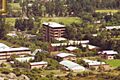
A building at Universidad del Valle (UNIVALLE) in Tiquipaya.
See also
 In Spanish: Tiquipaya para niños
