Tirrases facts for kids
Quick facts for kids
Tirrases
|
|
|---|---|
|
District
|
|

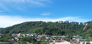
Tirrases, seen from Hacienda Vieja
|
|
| Nickname(s):
Tirra
|
|
| Country | |
| Province | San José |
| Canton | Curridabat |
| Creation | 21 August 1929 |
| Area | |
| • Total | 1.87 km2 (0.72 sq mi) |
| Elevation | 1,175 m (3,855 ft) |
| Population
(2011)
|
|
| • Total | 16,247 |
| • Density | 8,688/km2 (22,500/sq mi) |
| Demonym(s) | Tirraseño |
| Time zone | UTC−06:00 |
| Postal code |
11804
|
Tirrases is a special area called a district in the Curridabat region. It's part of the San José province in the beautiful country of Costa Rica.
Contents
What's in a Name?
The name Tirrases comes from a tree called the Tirrá tree. Its scientific name is Ulmus mexicana. So, the district is named after a type of tree!
A Look at History
Tirrases became a district on August 21, 1929. This happened when the larger area it belongs to, the Curridabat canton, was officially created. It was the 18th canton formed in the San José province.
Where is Tirrases?
Tirrases covers a small area of about 1.87 square kilometers. It sits at an elevation of 1175 meters above sea level. This means it's quite high up!
Who Lives in Tirrases?
According to the 2011 census, about 16,247 people live in Tirrases. The people who live here are called Tirraseños.
Getting Around
You can get to and from Tirrases using a few main roads. These are important for people to travel and move goods.
Learning in Tirrases
Education is important in Tirrases. Most people here have gone to school, but a small number (about 6.98%) haven't had formal education. The district has two public elementary schools:
- The Escuela Centroamérica
- The Escuela 15 de Agosto
For older students, there's a public high school called Colegio Técnico Profesional Uladislao Gámez Solano. This high school opened in 2006. In 2007, it had about 60 students. It's located near the Catholic Church of Las Mercedes.
Images for kids
See also
 In Spanish: Tirrases para niños
 | Jewel Prestage |
 | Ella Baker |
 | Fannie Lou Hamer |


