Trois Saumons River facts for kids
Quick facts for kids Trois Saumons River |
|
|---|---|
| Native name | Rivière Trois Saumons |
| Country | Canada |
| Province | Quebec |
| Region | Chaudière-Appalaches |
| MRC | L'Islet Regional County Municipality |
| Physical characteristics | |
| Main source | Lake Trois Saumons Saint-Aubert 428 metres (1,404 ft) 47°08′31″N 70°09′23″W / 47.1418835°N 70.156465°W |
| River mouth | St. Lawrence River L'Islet 4 metres (13 ft) 47°09′42″N 70°19′01″W / 47.16167°N 70.31694°W |
| Length | 17.0 kilometres (10.6 mi) |
| Basin features | |
| Tributaries |
|
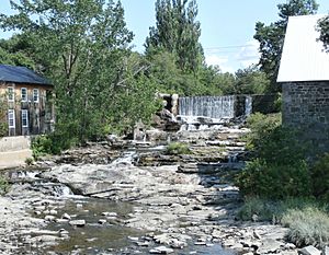
The Trois Saumons River (which means Three Salmon River in French) is a river in Quebec, Canada. It flows into the big St. Lawrence River. This river passes near the villages of Saint-Jean-Port-Joli and L'Islet-sur-Mer. You can even find an old water mill on the river near Saint-Jean-Port-Joli.
The Trois Saumons River travels through two main areas: Saint-Aubert and Saint-Jean-Port-Joli. Both of these are located in the L'Islet Regional County Municipality. This area is part of the Chaudière-Appalaches region in Quebec.
Where Does the River Start?
The Trois Saumons River begins its journey at a beautiful place called Trois Saumons Lake. This lake is 5.5 kilometres (3.4 mi) long and sits high up at 434 metres (1,424 ft) above sea level. It is located in the town of Saint-Aubert.
Trois Saumons Lake is a popular spot for fun and tourism. Many cabins are built along its edges, and it is surrounded by thick forests. This lake is about 9.4 kilometres (5.8 mi) away from the St. Lawrence River. It is also 6.2 kilometres (3.9 mi) south of Saint-Aubert village. The lake flows out from its northeast side, starting the river's path.
The River's Journey
The Trois Saumons River flows for a total of 17.0 kilometres (10.6 mi). Here is how its journey unfolds:
- First, it flows 2.1 kilometres (1.3 mi) northwest. It crosses the 5th rang East road in Saint-Aubert.
- Next, it travels 3.0 kilometres (1.9 mi) more to the northwest. Here, another river, the Trois Saumons East River, joins it.
- Then, the river turns west for 3.7 kilometres (2.3 mi). It crosses rue Principale Ouest and reaches the border between Saint-Aubert and Saint-Jean-Port-Joli.
- After that, it flows 3.2 kilometres (2.0 mi) northwest. It goes under Highway 20.
- Finally, the river travels 5.0 kilometres (3.1 mi) west. It crosses a railway line and goes under Route 132. This is where it meets the St. Lawrence River.
At the very end of its path, the Trois Saumons River flows into the Anse de Trois-Saumons. This is a bay on the south shore of the St. Lawrence River's middle estuary. This meeting point is 2.6 kilometres (1.6 mi) northeast of L'Islet-sur-Mer. It is also 6.8 kilometres (4.2 mi) southwest of Saint-Jean-Port-Joli.
Why is it Called Trois Saumons?
The name "Rivière Trois Saumons" was officially given to the river on December 5, 1968. This decision was made by the Commission de toponymie du Québec. This commission is in charge of naming places in Quebec. The name means "Three Salmon River."
See also
 | Percy Lavon Julian |
 | Katherine Johnson |
 | George Washington Carver |
 | Annie Easley |


