
Trowbridge Square Historic District facts for kids
Quick facts for kids |
|
|
Trowbridge Square Historic District
|
|

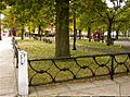
Houses north side of Trowbridge Square (1860s).
|
|

Location in Connecticut

Location in the United States
|
|
| Location | Roughly bounded by Columbus & Howard Aves., New Haven, Connecticut |
|---|---|
| Area | 26 acres (11 ha) |
| Built | 1830 |
| Architect | Thompson, Isaac; Multiple |
| Architectural style | Greek Revival, Italianate, Queen Anne |
| NRHP reference No. | 85002311 |
| Added to NRHP | September 12, 1985 |
The Trowbridge Square Historic District is a special neighborhood in New Haven, Connecticut. It's like a time capsule from the 1800s! This area was once called Village of Spireworth and Mount Pleasant. It became a historic district in 1985. You can find it near Columbus, Howard, and Union Avenues. Many of its old buildings and streets still look like they did long ago. They show different styles from the 1800s.
Contents
Exploring Trowbridge Square's History
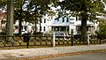
The Trowbridge Square Historic District is built around a small park called Trowbridge Square. This park is southwest of downtown New Haven. It's also close to the city's old port area. The streets around the park were planned in a grid shape. This was similar to how New Haven was first laid out in the 1600s.
Homes and Buildings in the District
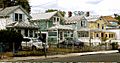
Most streets here have modest houses. They are usually 1.5 or 2.5 stories tall. These homes are made of wood and sit close to the street. They show different architectural styles from the 1830s to the early 1900s. You can see touches of Greek Revival, Italianate, and Queen Anne styles. Besides homes, you'll find the Sacred Heart church, school, and convent. These buildings are also from the same time period.
How Trowbridge Square Began
In the early 1800s, the Trowbridge Square area was mostly a shanty town. It was next to docks and tanneries. These were places where animal hides were processed. A local landowner named James Hillhouse wanted to develop the area in the 1810s. But money problems stopped his plans.
In 1830, Simeon Jocelyn and Isaac Thompson bought the land. They created the street plan for the new neighborhood. They named it "Spireworth." Jocelyn was a successful businessman. He wanted to create a good community for people who were poor or didn't have many advantages. This included many Black residents. He hoped they could improve their lives there.
Growth and Development of the Neighborhood
Building in the area was slow at first. But things changed in the 1850s. Thomas Trowbridge helped fund improvements to the park. He even paid for its fence. He also led the building of the church. Trowbridge built many small worker cottages in the district. These homes were mostly rented to laborers. He also built larger, more fancy Italianate houses in the Cedar Street area.
Gallery
-
Trowbridge Square towards the south side
-
Houses west side of Trowbridge Square (1870s)
-
Trowbridge Square towards the east side (1880s)
-

South Congregational Church (1851), Liberty St. and Columbus Ave., Sidney Mason Stone. (Sacred Heart Church from 1875)


