
Tube map facts for kids
The Tube Map is a special map that helps people find their way around London using different types of trains. It shows the London Underground (often called the "Tube"), the London Overground, the Docklands Light Railway, and the Emirates Air-line cable car. To make the map easy to understand, the train lines are drawn as straight lines, even though the real tunnels curve and bend underground.
This map was the first of its kind to use these clever simplifying tricks. Now, many transport maps all over the world use similar ideas! Transport for London (TfL) keeps adding new stations, lines, and ways to travel to the Tube Map. This amazing map helps over a billion people travel around London every year, making it easier to get around one of Europe's biggest cities.
Contents
How the Tube Map Helps You Travel
The Tube Map is super useful for planning journeys in London. It shows you all the different train lines and where they connect. You can see which stations are close to each other and how to switch from one line to another. This makes exploring London simple and fun!
A Smart Design for Everyone
The person who first designed the modern Tube Map was named Harry Beck. He realized that people underground didn't need to know the exact twists and turns of the tunnels. They just needed to know the order of the stations and where to change lines. His idea of straight lines and clear colors made the map much easier to read than older, more realistic maps.
Why Lines Are Straight on the Map
Imagine trying to read a map that showed every single curve and bend of the underground tunnels! It would be very messy and hard to follow. By making the lines straight, the map becomes clean and clear. Each line has its own color, so you can easily follow your route from one station to the next. This smart design helps millions of people navigate London every day.
Growing with London's Transport
The Tube Map is always changing! As London grows and new train lines or stations are built, they get added to the map. This means the map stays up-to-date and continues to be a helpful guide for everyone. It's a living map that changes as the city's transport system changes.
Images for kids
-
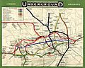
Map of underground lines, 1908
-
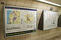
A London Buses "spider map" next to a Tube map at Waterloo Station


See also
 In Spanish: Mapa del Metro de Londres para niños
