Támesis, Antioquia facts for kids
Quick facts for kids
Támesis, Antioquia
|
|||
|---|---|---|---|
|
Municipality and town
|
|||
 |
|||
|
|||

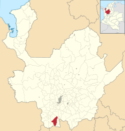
Location of the municipality and town of Támesis, Antioquia in the Antioquia Department of Colombia
|
|||
| Country | |||
| Department | |||
| Subregion | Southwestern | ||
| Area | |||
| • Municipality and town | 243 km2 (94 sq mi) | ||
| • Urban | 1 km2 (0.4 sq mi) | ||
| Elevation | 1,638 m (5,374 ft) | ||
| Population | |||
| • Municipality and town | 16,500 | ||
| Time zone | UTC-5 (Colombia Standard Time) | ||
| Website | http://www.tamesis-antioquia.gov.co/index.shtml | ||
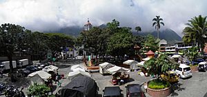
Támesis is a beautiful town and a municipality in Colombia. It is located in the Antioquia department, which is a part of Colombia. Támesis is also part of the Southwestern Antioquia region. The town sits high up, about 1,638 meters (5,374 feet) above sea level. It was founded a long time ago, in 1858. People in Támesis mostly work in farming, growing crops and raising animals.
Contents
Protecting Nature in Támesis
The mountains around Támesis are very important. One special mountain is called Cerro de Cristo Rey. This mountain is considered sacred by local Indigenous people. These mountains hold valuable minerals deep inside them.
Community Views on Mining
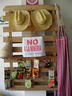
There have been ideas to dig for these minerals. However, many local people do not agree with these plans. Some residents are worried about mining in general. They believe it could harm the environment. Others are concerned about how mining activities are managed. They want to make sure that local communities and nature are protected.
Weather and Climate
Támesis has a warm and humid climate. This is typical for places located in tropical regions. The weather stays pretty consistent throughout the year.
Temperature and Rainfall
The average temperature in Támesis is around 22.6 degrees Celsius (72.7 degrees Fahrenheit). The warmest months are usually February and March. The town receives a lot of rain, especially from April to November. The wettest months are often May and October. Even with all the rain, there are still many sunny days. This helps the plants and crops grow well.
| Climate data for Támesis (Nacional Gja La), elevation 1,151 m (3,776 ft), (1981–2010) | |||||||||||||
|---|---|---|---|---|---|---|---|---|---|---|---|---|---|
| Month | Jan | Feb | Mar | Apr | May | Jun | Jul | Aug | Sep | Oct | Nov | Dec | Year |
| Mean daily maximum °C (°F) | 28.0 (82.4) |
29.0 (84.2) |
28.9 (84.0) |
27.7 (81.9) |
27.0 (80.6) |
27.2 (81.0) |
27.8 (82.0) |
28.3 (82.9) |
27.5 (81.5) |
26.5 (79.7) |
26.5 (79.7) |
26.9 (80.4) |
27.6 (81.7) |
| Daily mean °C (°F) | 22.7 (72.9) |
23.4 (74.1) |
23.4 (74.1) |
22.9 (73.2) |
22.5 (72.5) |
22.5 (72.5) |
22.7 (72.9) |
23.0 (73.4) |
22.4 (72.3) |
21.8 (71.2) |
22.0 (71.6) |
22.1 (71.8) |
22.6 (72.7) |
| Mean daily minimum °C (°F) | 18.3 (64.9) |
18.6 (65.5) |
18.8 (65.8) |
18.8 (65.8) |
18.8 (65.8) |
18.6 (65.5) |
18.2 (64.8) |
18.3 (64.9) |
18.3 (64.9) |
18.2 (64.8) |
18.5 (65.3) |
18.4 (65.1) |
18.5 (65.3) |
| Average precipitation mm (inches) | 85.9 (3.38) |
102.6 (4.04) |
148.4 (5.84) |
230.5 (9.07) |
291.3 (11.47) |
204.4 (8.05) |
192.3 (7.57) |
202.3 (7.96) |
278.5 (10.96) |
306.5 (12.07) |
246.9 (9.72) |
161.5 (6.36) |
2,451 (96.5) |
| Average precipitation days (≥ 1.0 mm) | 11 | 13 | 16 | 20 | 22 | 17 | 15 | 16 | 20 | 23 | 22 | 15 | 210 |
| Average relative humidity (%) | 81 | 79 | 80 | 83 | 86 | 85 | 82 | 81 | 83 | 86 | 86 | 85 | 83 |
| Mean monthly sunshine hours | 195.3 | 175.0 | 164.3 | 135.0 | 133.3 | 156.0 | 195.3 | 189.1 | 153.0 | 133.3 | 141.0 | 167.4 | 1,938 |
| Mean daily sunshine hours | 6.3 | 6.2 | 5.3 | 4.5 | 4.3 | 5.2 | 6.3 | 6.1 | 5.1 | 4.3 | 4.7 | 5.4 | 5.3 |
| Source: Instituto de Hidrologia Meteorologia y Estudios Ambientales | |||||||||||||
See also
 In Spanish: Támesis (Antioquia) para niños
 | Jessica Watkins |
 | Robert Henry Lawrence Jr. |
 | Mae Jemison |
 | Sian Proctor |
 | Guion Bluford |


