Verdugo (river) facts for kids
Quick facts for kids Verdugo |
|
|---|---|

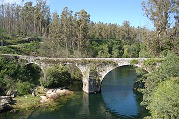
Medieval bridge over the Río Verdugo in Comboa.
|
|
| Country | Spain |
| Physical characteristics | |
| Main source | 760 m (2,490 ft) |
| River mouth | Ría de Vigo, Atlantic Ocean |
| Length | 41 km (25 mi) |
| Basin features | |
| Basin size | 357 km2 (138 sq mi) |
The Verdugo is a river found in the province of Pontevedra, which is in the region of Galicia, in north-western Spain. It flows for about 41 kilometers (25 miles).
This river begins high up in the mountains, about 760 meters (2,493 feet) above sea level. Its starting point is in a town called Forcarei. The Verdugo River then travels through the landscape until it reaches the Atlantic Ocean, specifically at the Ría de Vigo, close to the city of Pontevedra.
Contents
About the Verdugo River
The Verdugo River is an important natural feature in its area. It collects water from a basin that covers about 357 square kilometers (138 square miles). This means it gathers water from a large surrounding land area.
Where the River Starts and Ends
The journey of the Verdugo River is quite interesting.
- Source: The river's source is high in the mountains of Forcarei. This is where the river begins its flow as small streams.
- Mouth: The river ends its journey by flowing into the Atlantic Ocean. It joins the ocean at a place called the Ría de Vigo, which is a type of inlet or estuary.
River Length and Elevation
The Verdugo River is not one of the longest rivers, but it plays a key role in the local environment.
- It measures approximately 41 kilometers (25 miles) from where it starts to where it meets the ocean.
- The elevation of its source, at 760 meters (2,493 feet), shows that it begins in a hilly or mountainous region. This high starting point helps the river flow downwards towards the sea.
See also
- Rivers of Galicia
 In Spanish: Río Verdugo para niños
 | Lonnie Johnson |
 | Granville Woods |
 | Lewis Howard Latimer |
 | James West |

