
Viaduct Harbour facts for kids
Quick facts for kids
Viaduct Harbour
|
|
|---|---|
|
Suburb
|
|

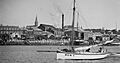
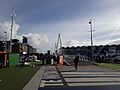
Lighter Basin area, at the western edge of the Viaduct Harbour
|
|

Viaduct Harbour
Location in New Zealand
|
|
| Country | New Zealand |
| Local authority | Auckland |
| Electoral ward | Waitematā and Gulf ward |
| Local board | Waitematā Local Board |
| Established | 1990s (redeveloped as a residential / entertainment area) |
| Area | |
| • Land | 60 ha (150 acre) |
| Population
(June 2023)
|
|
| • Total | 1,220 |
|
|
||
Viaduct Harbour, once called Viaduct Basin, is a cool area in Auckland, New Zealand. It used to be a busy port for ships. Now, it's a modern place with fancy apartments, offices, and lots of restaurants. It was built on an old, run-down part of the Auckland waterfront. Viaduct Harbour became super popular when it hosted the 2000 America's Cup sailing race and the 2022 Rally New Zealand. Both locals and visitors love this lively spot.
Contents
Who Lives in Viaduct Harbour?
The area called Wynyard-Viaduct, which includes Viaduct Harbour and Wynyard Quarter, is about 0.60 square kilometers. In 2023, about 1,220 people lived here. This means there are many people living close together!
The number of people living here has grown a lot. In 2006, there were 699 people. By 2018, the population had reached 1,008 people.
Most people living here are from Europe (75.3%). There are also people from Asia (18.8%), Māori (3.6%), and Pacific peoples (1.8%). Many people (53%) were born outside New Zealand.
Most people (57.4%) said they didn't have a religion. About 30.4% were Christian.
Many adults (51.1%) have a university degree. The average income here is higher than the national average. Most adults (66.6%) work full-time.
History of Viaduct Harbour
Why Was the Harbour Built?
_(cropped).jpg)
The Viaduct Basin was designed like the basins you might see in London. It was planned by the Auckland Harbour Board a long time ago, in the early 1900s. Ships were getting much bigger, and the harbour wasn't deep enough.
The idea was to have big cargo ships stay out in the Waitematā Harbour. Smaller boats called "lighters" would then carry the goods to special wharves in the new basin. But shipping companies didn't like this plan. They made the Harbour Board dig the harbour deeper and build new wharves instead.
So, the partially built lighter basin didn't have a clear purpose. It ended up being used for fishing boats. This helped make the Auckland waterfront look tidier. A fish market and warehouses were built next to it. For most of the 20th century, this area was the main center for Auckland's fishing industry.
Shipbuilding in the Area
Before the basin was built, there were timber mills near Freemans Bay. Many businesses related to shipbuilding, like foundries, were also in the area for a long time.
Boat building started in Freemans Bay in 1864. Many shipyards were built along the waterfront. Here are some of the important ones:
- Charles Bailey started many firms. He built ships like the PS Britannia in 1885. Later, his sons started C & W Bailey.
- William George Lowe worked with Charles Bailey. He later formed Bailey & Lowe with Walter Bailey.
- Charles Bailey & Son had a yard at Beaumont Street. This yard built several ships for the Devonport Steam Ferry.
- W G Lowe & Son took over the Beaumont yard in 1927. During World War II, they helped build minesweepers for the navy, like the Hinau and Manuka.
- Mason Brothers also had a yard in Beaumont Street. They built steel ships.
- Senior Foundry was another company in Beaumont Street that built ships.
- Seagar Brothers worked on ship machinery.
- John Bigelow had a yard on Customs Street West. He also helped raise sunken ships.
- William Hoile Brown had yards near Hobson Street. Later, Percy Vos and Shipbuilders Ltd took over these yards. The Percy Vos yard is now part of the New Zealand Maritime Museum.
- James William Carr had a boatyard near Nelson Street.
- Duthie & Ross launched a large steamer called Golden Crown in 1870.
- David Gouk built the scow Dominion in 1908. His company also built wharves and bridges.
- Henderson and Spraggon was founded by Adam Henderson.
- C Hewson and R Melville had a yard near Princes Street.
- Robert Logan had a yard on Customs Street West.
- Captain Richard Mackay built ships like the brigantine Defiance.
- George Niccol had a yard near the Kauri Timber Company depot.
A New Life for the Harbour
In 1995, Russell Coutts and Team New Zealand won the 1995 America's Cup sailing race. This meant Auckland would host the next race in 2000. The Viaduct Basin was completely changed to get ready for the America's Cup teams.
After the big sailing competition, the area became a mix of apartments and restaurants. It's now a popular place for people to live, work, and eat. In 2011, the area next to Viaduct Harbour, called the Western Reclamation, was also redeveloped into Wynyard Quarter.
Images for kids
-
R Logan shipyard and Gleeson's Hotel, Freeman's Bay in 1904
-
Lena at Bailey and Lowe yard and Gleeson's Hotel in 1905
-
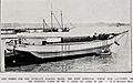
Dominion launch by C Gouk in 1908
-
Gleeson's Hotel and W H Brown shipyard at the foot of Hobson Street in 1909
-
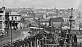
Bailey & Lowe and Robert Logan shipyards, Customs Street West, Freeman's Bay about 1919
-
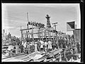
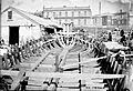
HMNZS Waikato launched from Beaumont Street on 16 October 1943
-
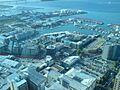
The quarter seen from the Sky Tower, with approximate boundaries shown marked in red
-
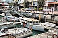
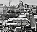
The original redevelopment on the eastern side of the Viaduct Harbour
-
Drawbridge linking the Viaduct Harbour to the Wynyard Quarter in Auckland


