Villa Tapia facts for kids
Quick facts for kids
Villa Tapia
|
||
|---|---|---|

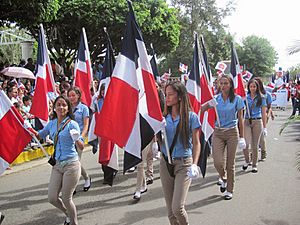
Dominicans in Villa Tapia town
|
||
|
||
| Country | ||
| Province | Hermanas Mirabal | |
| Created as municipality | February 27, 1850 | |
| Area | ||
| • Total | 90.12 km2 (34.80 sq mi) | |
| Population
(2012)
|
||
| • Total | 28,565 | |
| • Density | 316.966/km2 (820.94/sq mi) | |
| Distance to – Salcedo |
10 km |
|
| Municipal Districts | 0 |
|
Villa Tapia is a lively town located in the Hermanas Mirabal Province in the beautiful Dominican Republic. It is a place with its own unique history and community.
Contents
Discover Villa Tapia
Villa Tapia is a town that is part of the Hermanas Mirabal Province. This province is named after three brave sisters. The town itself is an important part of the local area.
Where is Villa Tapia Located?
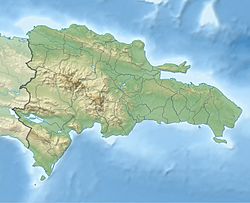
Villa Tapia is found in the northern part of the Dominican Republic. It is about 10 kilometers away from Salcedo, which is the main city of the Hermanas Mirabal Province. Its exact location helps us understand its climate and natural surroundings.
Geographic Coordinates
The town's coordinates are 19 degrees, 18 minutes, 0 seconds North and 70 degrees, 25 minutes, 12 seconds West. These numbers help pinpoint its exact spot on a map of the world.
How Big is Villa Tapia?
The total area of Villa Tapia is about 90.12 square kilometers. This gives you an idea of how much land the town covers. It's a good size for a community to live and grow.
People of Villa Tapia
In 2012, the total population of Villa Tapia was around 28,565 people. This number tells us how many residents call Villa Tapia home. The people living here make up the heart of the community.
When Was Villa Tapia Established?
Villa Tapia officially became a municipality on February 27, 1850. This date marks an important moment in the town's history. It was when it gained its own local government and became a recognized town.
See also
 In Spanish: Villa Tapia para niños
 | James B. Knighten |
 | Azellia White |
 | Willa Brown |


