Wôlinak facts for kids
Quick facts for kids
Wôlinak
|
|
|---|---|

Wôlinak village
|
|

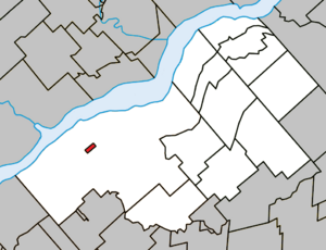
Location within Bécancour RCM.
|
|
| Country | |
| Province | |
| Region | Centre-du-Québec |
| RCM | None |
| Constituted | unspecified |
| Government | |
| • Type | Band council |
| Area | |
| • Total | 0.80 km2 (0.31 sq mi) |
| • Land | 0.74 km2 (0.29 sq mi) |
| Population
(2021)
|
|
| • Total | 194 |
| • Density | 262.8/km2 (681/sq mi) |
| • Pop 2016-2021 | |
| • Dwellings | 106 |
| Time zone | UTC−5 (EST) |
| • Summer (DST) | UTC−4 (EDT) |
| Area code(s) | 450 |
| Highways | No major routes |
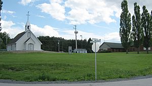
Wôlinak is a special place in Quebec, Canada. It is an First Nations reserve for the Abenaki people. This community is located inside the city of Bécancour. Long ago, Wôlinak was one of the important groups known as the Seven Nations of Canada.
The Wôlinak Reserve covers about 80.4 hectares, which is like 200 acres. It sits right next to the Bécancour River. This area is about 20 kilometers southeast of a bigger city called Trois-Rivières.
Contents
A Glimpse into Wôlinak's Past
Around the year 1600, some Abenaki and Sokokis families decided to settle near a river. This river was first called the Puante River. Later, it was renamed the Bécancour River after a person named M. de Bécancour. He was also living in the area.
Early Challenges and Changes
At first, about 600 people lived in the community. However, their numbers sadly went down. This happened because of wars and illnesses that spread through the area.
How the Land Became a Reserve
The land for the Wôlinak Reserve has a long history. On April 30, 1708, a man named Pierre Robineau gave a part of the Bécancour area to the Abenaki people. This was a very important step.
Later, in 1851, a law was passed in Canada. This law allowed for about 230,000 acres of land to be set aside for different Indigenous groups in Lower Canada.
Official Land Allotment
On June 8, 1853, a government official named John Rolph suggested how these lands should be given out. He proposed that the Abenaki people of Bécancour should receive 2,000 acres. This plan was approved by the government on August 9, 1853.
Mapping the Reserve Land
By January 27, 1873, a detailed map of the Bécancour area was made. This map clearly showed that certain parts of the land, about 150.13 acres, belonged to the Abenaki people.
Changes to the Reserve's Borders
Over the years, the reserve's land area changed a few times.
Railway and Land Sales
On November 17, 1913, the Canadian government sold a small piece of the reserve land. This piece, about 13.23 acres, was sold to a railway company to build train tracks.
However, the government bought this land back on January 14, 1946. It was then owned by the Canadian National Railway Company. This land was officially added back to the reserve on January 18, 1972.
Adding More Land
On September 19, 1972, the Canadian government bought more land from the Canadian National Railway Company. This added about 27.71 acres to the reserve. These new lands were officially made part of the Bécancour Indian Reserve on October 4, 1973.
A New Name for the Reserve
On June 30, 1983, the Bécancour Indian Reserve got a new name. It was officially changed to the "Wôlinak Indian Reserve."
Today, the Wôlinak Reserve is a vibrant home for the Abenaki First Nation. The community works hard to keep its traditional ways of life alive while also embracing modern times.
 | Roy Wilkins |
 | John Lewis |
 | Linda Carol Brown |


