Walker Creek (Marin County, California) facts for kids
Quick facts for kids Walker Creek |
|
|---|---|
|
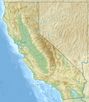
Location of the mouth of Walker Creek in California
|
|
| Country | United States |
| State | California |
| Region | Marin County |
| District | West Marin |
| Physical characteristics | |
| Main source | Confluence of Arroyo Sausal and Salmon Creek 233 ft (71 m) 38°09′42″N 122°41′16″W / 38.16167°N 122.68778°W |
| River mouth | Tomales Bay south of Preston Point 0 ft (0 m) 38°12′30″N 122°55′49″W / 38.20833°N 122.93028°W |
| Length | 18.5 mi (29.8 km) |
| Basin features | |
| Tributaries |
|
Walker Creek is a stream in western Marin County, California, in the United States. It flows towards the northwest. This creek starts where two other creeks, Salmon Creek and Arroyo Sausal, meet. Walker Creek then flows into Tomales Bay, which is a large inlet of the Pacific Ocean.
Contents
History of the Creek Names
Walker Creek got its name from an early landowner in the area. His name was Lewis W. Walker.
Chileno Creek is named after Chilean immigrants. These people settled in the Chileno Valley. They were encouraged to come by Adrian Godoy.
Keys Creek is named after an Irish settler named John Keyes. He settled by the creek in 1849. He used this creek to move farm products to San Francisco.
Where Walker Creek Flows
The area that drains into Walker Creek is called its watershed. This watershed covers about 76 square miles (200 km2). The land in this area goes from about 1,500 feet (460 m) high down to sea level. Walker Creek flows into Tomales Bay at sea level.
Walker Creek itself begins when Arroyo Sausal and Salmon Creek join together.
Arroyo Sausal's Journey
Arroyo Sausal starts at about 789 feet (240 m) high. It flows northwest, crossing a road called Point Reyes-Petaluma Road. It then goes into Hicks Valley and west to Soulajule Reservoir. This reservoir was built in 1968 on Arroyo Sausal. The Marin Municipal Water District manages it.
It is advised not to eat fish caught in Soulajule Reservoir. This is because certain substances have been found in the fish.
After the reservoir, Arroyo Sausal joins Walker Creek. This meeting point is at about 236 feet (72 m) high, near Marshall-Petaluma Road.
Salmon Creek's Journey
Salmon Creek starts at 800 feet (240 m) high. It flows west for about 4.5 miles (7.2 km). It follows Hicks Valley Road and then Marshall-Petaluma Road. It meets Arroyo Sausal to form Walker Creek.
In the past, Salmon Creek was a place where salmon and steelhead trout (a type of fish) would lay their eggs. However, farming practices and pollution have caused damage to the creek.
Walker Creek's Path to the Bay
From where Arroyo Sausal and Salmon Creek meet, Walker Creek flows northwest. It runs next to Marshall-Petaluma Road. The creek then crosses under the road and turns northwest again. It passes the mouth of Frink Canyon.
Next, it meets Chileno Creek. Chileno Creek starts at Laguna Lake. This lake is about 220-acre (89 ha) big. It sits on the border between Sonoma and Marin counties. Chileno Creek flows west for about 6.25 miles (10.06 km) to join Walker Creek.
After Chileno Creek, Walker Creek winds westward. It passes south of the town of Tomales, California. It goes under Highway 1. Right after that, Keys Creek joins Walker Creek from the north.
Keys Creek starts at 290 feet (88 m) high. It flows west for about 3.5 miles (5.6 km) through Tomales town. Below Tomales, it joins Walker Creek.
After Keys Creek, Walker Creek continues south along Highway 1. It then flows into Tomales Bay, just east of Preston Point.
Animals and Nature
In the early 1900s, many coho salmon lived in Walker Creek. But their numbers dropped a lot. This was likely due to too much grazing by animals and logging. These activities caused soil to wash into the creek.
In 1975, a study looked at steelhead trout and coho salmon. It found only a few young steelhead in the creek. Only eight coho salmon were found near where Chileno and Walker Creek meet. Also, a dam on Soulajule Reservoir stopped fish from swimming upstream to Arroyo Sausal.
Efforts began in 2003 to bring coho salmon back to Walker Creek. These efforts have had some success. In 2008 and 2013, coho salmon returned to Walker Creek, Salmon Creek, and Frink Canyon. If you want to fish for steelhead, you can only do so below Highway 1.
Parts of Keys Creek were once wide enough for barges. Barges are flat boats used to carry goods. Farmers used them to ship potatoes to San Francisco. Today, this part of the creek is much smaller. This shows how much soil has washed into the creek over the last 150 years.
Mercury was mined in the Walker Creek watershed until the early 1970s. This happened at several places, including the Gambonini and Chileno Valley mines. Soulajule Reservoir was built after a drought. It covered some of these old mine sites and piles of leftover mining waste. The biggest mine, at Gambonini Ranch, closed in 1970.
 | May Edward Chinn |
 | Rebecca Cole |
 | Alexa Canady |
 | Dorothy Lavinia Brown |


