Webb Island facts for kids
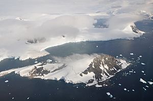
Webb Island is a small, rocky island located in the cold, icy region of Antarctica. It's about 2.8 kilometers (1.5 nautical miles) long. You can find it in a place called Laubeuf Fjord, which is near a larger landmass known as Adelaide Island. It lies about 6 kilometers (3 nautical miles) south of the entrance to Stonehouse Bay.

Discovering Webb Island
Webb Island was first explored and named by a French expedition. This group was led by a famous French explorer named Jean Baptiste Charcot. His team explored the Antarctic region between 1908 and 1910.
How Webb Island Got Its Name
Jean Baptiste Charcot decided to name the island after Captain Richard C. Webb. At that time, Captain Webb was an officer in the British Royal Navy. He was in charge of a British warship located in waters near Argentina. Later, Captain Webb became an Admiral.

Where is Webb Island?
Webb Island is part of a group of islands and landforms around Adelaide Island. It's located in Laubeuf Fjord, which is a long, narrow inlet of the sea. This fjord cuts into the land, surrounded by mountains and ice.
Nearby Features
- Adelaide Island: A much larger island close to Webb Island.
- Laubeuf Fjord: The body of water where Webb Island is located.
- Stonehouse Bay: A bay located north of Webb Island.
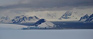
- Wormald Ice Piedmont: An ice-covered slope on Adelaide Island, from where one of the pictures of Webb Island was taken.
- Wyatt Island: Another island visible in the distance from Webb Island.
- Arrowsmith Peninsula: A part of the Antarctic mainland with mountains that can be seen from Webb Island.
 | Percy Lavon Julian |
 | Katherine Johnson |
 | George Washington Carver |
 | Annie Easley |

