Weber County, New Zealand facts for kids
Quick facts for kids Weber County |
|
|---|---|
| County of New Zealand | |
| 1902–1956 | |
| History | |
|
• Established
|
1902 |
|
• Disestablished
|
1956 |
| Today part of | Tararua District |
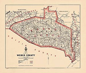
Weber County was a special area in the North Island of New Zealand. It was one of the many counties that existed in the past. This county was located in a place once known as the Seventy Mile Bush.
The small town of Weber was part of this county. Most people in the area raised sheep, which was the main type of farming.
Contents
What Was Weber County?
Weber County was a small area, about 95 sq mi (250 km2) (246 square kilometers) in size. It was created in 1902. Before that, it was part of the Weber Road Board and a piece of the Patangata County.
Where Was Weber County Located?
Weber County had neighbors all around it. To the south, it bordered Akitio County. To the north-east, it was next to the rest of Patangata County. On its north-west side, it bordered Dannevirke County. For a short time until 1907, it bordered Waipawa County instead.
When Did Weber County End?
Weber County eventually joined with Dannevirke County in 1956. Akitio County, its neighbor to the south, also merged with Dannevirke County later in 1976.
How Was Weber County Run?
The government of Weber County was managed by the Weber County Council. This council was officially started by a law called The Weber County Act in 1902.
Council Meetings and Office
The very first meeting of the Weber County Council happened on 20 February 1903. The main office for the county was located at a place called Ti-tree Point. This office was on Route 52, about 10 km (6.2 mi) east of the town of Weber.
Life in Weber County
Over the years, the number of people living in Weber County slowly went down. In 1906, there were 593 people. By 1911, it dropped to 525, and by 1951, only 340 people lived there.
Who Paid Taxes?
In 1927, there were only 78 "ratepayers." Ratepayers were people who owned property and paid local taxes to the county council.
County's Main Job
The most important job for the county council was taking care of the roads. However, because there were so few people and not much money, it was hard for the county to pay for everything. For example, in 1922, they had a steam roller to help build roads, but they didn't even have a grader, which is another important machine for road work.
Electricity Comes to Weber
Electricity started to arrive in some parts of Weber County around 1939, bringing modern power to the area.
 | Ernest Everett Just |
 | Mary Jackson |
 | Emmett Chappelle |
 | Marie Maynard Daly |


