Wellesley Island facts for kids
Wellesley Island is a cool island in New York State. It's found in Jefferson County and is split between two towns: Orleans and Alexandria. This island is a popular spot, especially in the summer, and is home to many fun places to visit.
Contents
Island History
Long ago, this island was called Wells Island. But in 1815, a captain named William Fitzwilliam Owen changed its name. He wanted to honor a famous leader, Arthur Wellesley, who was the Duke of Wellington. That's how it became Wellesley Island! Some places on the island were even named after the Duke's famous battles, but those names didn't last. For example, the big bay inside the island is called Lake of the Isles, not Lake Waterloo.
Island Geography
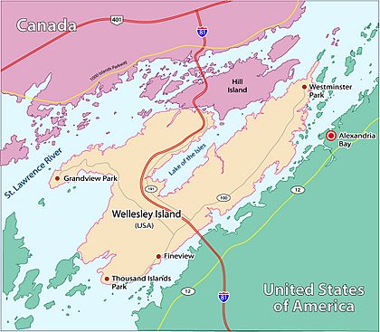
Wellesley Island is located in the beautiful St. Lawrence River. The river wraps around three sides of the island. What's really cool is that the island also has its own large body of water inside it, called the Lake of the Isles. This lake almost doubles the amount of waterfront the island has! The eastern part of the island is right across from the village of Alexandria Bay.
A major highway, Interstate 81, crosses Wellesley Island. This highway is part of the amazing Thousand Islands Bridge system. Five different bridge sections connect the island to the river's opposite shores. One of these bridges crosses a small channel called the International Rift. This channel separates Wellesley Island in the United States from Hill Island in Canada. The place where people cross the border into the United States is on the northeastern part of Wellesley Island.
Wellesley Island is one of the biggest islands in the Thousand Islands area of the St. Lawrence River. Many people live here all year round, but the number of people grows a lot during the summer. The island has two State Parks, a nature center where you can learn about local wildlife, and three golf courses. At the southern tip of the island is Thousand Island Park, a historic community listed on the National Register of Historic Places since 1982. Besides Interstate 81, other roads like Jefferson County Routes 100 and 191 also help people get around the island.
Island Features
- Barnett Marsh—A wet, swampy area in the southern part of the island.
- Densmore Bay—A bay on the south shore of the island's southeast section.
- Eel Bay—A large bay found between Wellesley Island and Grindstone Island.
- Lake of the Isles—A body of water connected to the St. Lawrence River. It lies between the island's northeast and southeast parts.
- South Bay—A bay on the southwest side of the island.
Communities on the Island
- Grandview
- Moore Landing
- Fineview
- Thousand Island Park
- Westminster Park
Parks on the Island
- Wellesley Island State Park—This park has several different areas across the island.
- Dewolf Point State Park—Located along the Lake of the Isles on the southeast side of the northern part of the island.
- Waterson Point State Park—Found on the northern edge of the island, close to the border with Canada.
- Mary Island State Park—While not directly on Wellesley Island, this park is very close. You can only get to it by water, and it's separated from the easternmost tip of Wellesley Island by a small channel.
See also
 In Spanish: Isla Wellesley para niños
 | Mary Eliza Mahoney |
 | Susie King Taylor |
 | Ida Gray |
 | Eliza Ann Grier |


