West Hattiesburg, Mississippi facts for kids
Quick facts for kids
West Hattiesburg, Mississippi
|
|
|---|---|

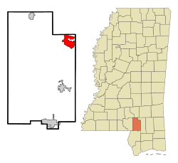
Location of West Hattiesburg, Mississippi
|
|
| Country | United States |
| State | Mississippi |
| County | Lamar |
| Area | |
| • Total | 2.49 sq mi (6.45 km2) |
| • Land | 2.41 sq mi (6.25 km2) |
| • Water | 0.08 sq mi (0.20 km2) |
| Elevation | 253 ft (77 m) |
| Population
(2020)
|
|
| • Total | 6,006 |
| • Density | 2,489.02/sq mi (960.87/km2) |
| Time zone | UTC−6 (Central (CST)) |
| • Summer (DST) | UTC−5 (CDT) |
| FIPS code | 28-78890 |
| GNIS feature ID | 2403004 |
West Hattiesburg is a community in Lamar County, Mississippi. It is an unincorporated area, meaning it does not have its own local government like a city or town. It is also a census-designated place (CDP), which is a special area created by the U.S. Census Bureau for collecting population data.
West Hattiesburg is located west of the city of Hattiesburg and east of Oak Grove. It is part of the larger Hattiesburg metropolitan area. In 2020, about 6,006 people lived in West Hattiesburg.
Contents
Geography of West Hattiesburg
West Hattiesburg is found in the northeastern part of Lamar County. The city of Hattiesburg borders it to the north, east, and south.
The size of West Hattiesburg has changed over time. In 2000, it was about 7.2 square miles (18.6 square kilometers). By 2019, its area had become smaller, at 6.45 square kilometers (2.49 square miles). This change happened because parts of the land were added to the city of Hattiesburg.
A small part of West Hattiesburg, about 0.2 square kilometers (0.08 square miles), is covered by water. The main body of water in the community is Lairds Lake.
People of West Hattiesburg
| Historical population | |||
|---|---|---|---|
| Census | Pop. | %± | |
| 2020 | 6,006 | — | |
| U.S. Decennial Census | |||
Population in 2020
According to the 2020 United States census, there were 6,006 people living in West Hattiesburg. These people lived in 2,387 households, and 1,478 of these were families.
The table below shows the different groups of people living in West Hattiesburg in 2020:
| Race | Number of People | Percentage |
|---|---|---|
| White (not Hispanic or Latino) | 2,055 | 34.22% |
| Black or African American (not Hispanic or Latino) | 2,849 | 47.44% |
| Native American | 8 | 0.13% |
| Asian | 173 | 2.88% |
| Pacific Islander | 22 | 0.37% |
| Other/Mixed (two or more races) | 258 | 4.3% |
| Hispanic or Latino | 641 | 10.67% |
Becoming a City
For many years, some people in West Hattiesburg have wanted the area to become an official city. This process is called incorporation. If West Hattiesburg became a city, it would have its own local government and be able to make its own rules and collect taxes.
People who support incorporation believe it would help everyone in the community. However, those who are against it worry that it might mean higher taxes for residents. They also question if the new city would have enough money to cover all its costs. This debate shows how local politics can be complicated, with different groups having different ideas about what is best for the community.
How "West Hattiesburg" Got Its Name
For a long time, people who lived in the area didn't really use the name "West Hattiesburg." The name became popular because people from outside the area saw it listed on Google Maps. The name originally came from the U.S. Census Bureau, which uses it for counting people. Now, more and more local residents are starting to use the term.
It's important not to confuse West Hattiesburg with Oak Grove. Oak Grove is a separate community located just to the west. Even though West Hattiesburg is its own area, many students who live there go to schools in the Oak Grove school system.
Roads and Traffic
Two major highways are close to West Hattiesburg. Interstate 59 runs along the eastern edge of the community. U.S. Highway 98 passes just north of West Hattiesburg, through land that is now part of Hattiesburg.
Because more people have moved to this area and Lamar County recently, traffic on Highway 98 has become much heavier. To help with this, Highway 98 has been made wider, from four lanes to six, and in some parts near Interstate 59, it has even been widened to eight lanes. Other important roads that run parallel to Highway 98, like 4th Street, Oak Grove Road, and Lincoln Road, also see a lot of traffic as drivers try to avoid the busiest parts of Highway 98.
Education in West Hattiesburg
Students in West Hattiesburg are served by the Lamar County School District. They attend schools that are part of the neighboring Oak Grove school system. Because the population has grown, some people have suggested that the district should build new schools specifically for West Hattiesburg.
High School
- Oak Grove High School (for students in grades 9-12)
Middle School
- Oak Grove Middle School (for students in grades 6-8)
Elementary Schools
- Oak Grove Upper Elementary School (for students in grades 4-5)
- Oak Grove Lower Elementary School (for students in grades 2-3)
- Long Leaf Elementary School (for students in grades K-5)
- Oak Grove Primary School (for students in grades K-1)
See also
 In Spanish: West Hattiesburg para niños


