Wever, Iowa facts for kids
Quick facts for kids
Wever, Iowa
|
|
|---|---|

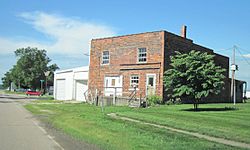
Building in Wever
|
|
| Country | United States |
| State | Iowa |
| County | Lee |
| Area | |
| • Total | 1.48 sq mi (3.82 km2) |
| • Land | 1.48 sq mi (3.82 km2) |
| • Water | 0.00 sq mi (0.00 km2) |
| Elevation | 561 ft (171 m) |
| Population
(2020)
|
|
| • Total | 101 |
| • Density | 68.43/sq mi (26.42/km2) |
| Time zone | UTC-6 (Central (CST)) |
| • Summer (DST) | UTC-5 (CDT) |
| ZIP codes |
52658
|
| FIPS code | 19-84855 |
| GNIS feature ID | 462957 |
Wever is a small, unincorporated community in the state of Iowa, United States. It is located in the northeastern part of Lee County. An "unincorporated community" means it's a group of homes and businesses that isn't officially a city or town with its own local government. As of 2020, about 101 people lived in Wever.
Contents
Where is Wever Located?
Wever is found along U.S. Route 61, a major highway. It's about eight miles northeast of Fort Madison. Fort Madison is one of the two main cities in Lee County where the county government offices are located.
Wever is also close to the Iowa Army Ammunition Plant. This is a large facility that makes ammunition for the military. The community is also near the Skunk River, which flows into the Mississippi River further east. Wever sits at an elevation of 561 feet (171 meters) above sea level.
How Many People Live in Wever?
| Historical population | |||
|---|---|---|---|
| Census | Pop. | %± | |
| 2020 | 101 | — | |
| U.S. Decennial Census | |||
According to the United States Census in 2020, the population of Wever was 101 people.
A Look at Wever's Past
Wever started as a stop along the Chicago, Burlington and Quincy Railroad. This railroad was very important for transportation and trade in the past.
The Post Office Story
Even though Wever isn't an official city, it has its own post office. This post office first opened a very long time ago, on May 1, 1837. It has had a few different names over the years:
- It first opened as 'Sand Ridge'.
- Then, on September 17, 1849, its name changed to 'Green Bay'.
- On January 28, 1859, it became 'Jollyville'.
- Finally, on October 17, 1870, it was named 'Wever'.
Today, Wever's ZIP code is 52658.
Growth of the Community
Wever grew up around the railroad station. It took the place of an older nearby town called Jollyville. In 1879, a history book about Lee County mentioned that Wever had about 300 people. It was a busy place for trade because the land around it was very good for farming. By 1902, Wever's population was 66, and it grew to 212 people by 1925.
Wever is part of a larger area called the Fort Madison-Keokuk μSA. This means it's connected economically to the nearby cities of Fort Madison and Keokuk.
Modern Times in Wever
The Fertilizer Plant
In 2012, there was big news for Wever. Plans were announced to build a very large fertilizer plant in the community. This plant would cost about $1.4 billion to build. It uses natural gas to make fertilizers.
The company Orascom built the plant, and construction began in November 2012. The Wall Street Journal, a famous newspaper, wrote that the plant was being built because the U.S. economy was getting stronger. Also, natural gas was cheaper due to new ways of getting it from shale rock. This made companies like Orascom from Egypt want to invest in the area.
 | Kyle Baker |
 | Joseph Yoakum |
 | Laura Wheeler Waring |
 | Henry Ossawa Tanner |


