Whangamarino railway station facts for kids
Quick facts for kids
Whangamarino Railway Station
|
|
|---|---|

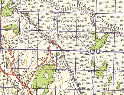
1942 Whangamarino railway station
on N52 one inch map |
|
| Location | Whangamarino New Zealand |
| Coordinates | 37°20′53″S 175°06′50″E / 37.348053°S 175.113916°E |
| Owned by | KiwiRail Network |
| Line(s) | North Island Main Trunk |
| Tracks | single |
| History | |
| Opened | 13 August 1877 |
| Closed | 2 February 1969 to passengers 25 June 1978 to goods |
The Whangamarino Railway Station was a small train stop in the Waikato District of New Zealand. It was located about 49 miles (79 km) south of Auckland. This station was part of the important North Island Main Trunk railway line. A 'flag station' meant that trains would only stop there if someone waved a flag to get on, or if a passenger on the train asked to get off.
Station History
The Whangamarino Railway Station first opened its doors on August 13, 1877. In the early days, trains from Whangamarino traveled quite slowly. They averaged about 13 miles per hour (21 km/h). This meant a trip to Auckland could take around four hours.
Track Upgrades
In 1914, plans were made to add a second track to the railway line. This was to help ease traffic and make train travel smoother. However, World War I caused delays in starting this work. Because of these delays, the railway line at Whangamarino remained a single track.
There have been ideas to double the track more recently. One idea involved using extra soil from the City Rail Link project in Auckland. This project aimed to build new underground train tunnels in the city.
Station Closure
The Whangamarino Railway Station eventually closed down. It stopped serving passengers on February 2, 1969. Later, on June 25, 1978, it also stopped handling goods. This meant the station was no longer in use for any train services.
 | Aurelia Browder |
 | Nannie Helen Burroughs |
 | Michelle Alexander |


