Wrightstown, Pennsylvania facts for kids
Quick facts for kids
Wrightstown, Pennsylvania
|
|
|---|---|
|
Unincorporated community
|
|

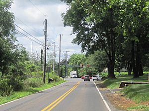
Approaching center of Wrightstown from the east
|
|
| Country | United States |
| State | Pennsylvania |
| County | Bucks |
| Township | Wrightstown |
| Elevation | 364 ft (111 m) |
| Time zone | UTC-5 (Eastern (EST)) |
| • Summer (DST) | UTC-4 (EDT) |
| Area code(s) | 215, 267, and 445 |
| GNIS feature ID | 1204999 |
Wrightstown is a small, special type of community in Pennsylvania, United States. It's not a city or a town with its own government. Instead, it's part of a larger area called Wrightstown Township. You can think of it like a neighborhood within a bigger township.
What is an Unincorporated Community?
Wrightstown is known as an unincorporated community. This means it doesn't have its own separate local government. For example, it doesn't have its own mayor or a town council just for Wrightstown itself. Instead, it is governed by the larger Wrightstown Township. Many small places in the United States are unincorporated communities. They are often just groups of homes and businesses that share a name.
Where is Wrightstown Located?
Wrightstown is found in Bucks County, Pennsylvania. This county is in the southeastern part of Pennsylvania. The community is located where two roads meet. These roads are Pennsylvania Route 413 and Worthington Mill Road/Wrightstown Road. This intersection helps people find the center of Wrightstown.


