Yacuanquer facts for kids
Quick facts for kids
Yacuanquer
|
||
|---|---|---|
|
Municipality and town
|
||
|
||

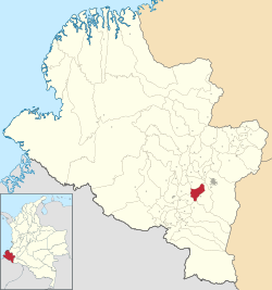
Location of the municipality and town of Yacuanquer in the Nariño Department of Colombia.
|
||
| Country | ||
| Department | Nariño Department | |
| Area | ||
| • Municipality and town | 111 km2 (43 sq mi) | |
| Elevation | 2,670 m (8,760 ft) | |
| Population
(Census 2018)
|
||
| • Municipality and town | 10,579 | |
| • Density | 95.3/km2 (246.8/sq mi) | |
| • Urban | 2,815 | |
| Time zone | UTC-5 (Colombia Standard Time) | |
Yacuanquer is a town and a special area called a municipality in the Nariño Department of Colombia. It is located high up in the mountains.
Contents
What is the Climate Like in Yacuanquer?
Yacuanquer has a cool climate because it is very high above sea level. The weather does not change much throughout the year. It is usually mild, not too hot and not too cold.
Temperatures in Yacuanquer
The average temperature in Yacuanquer is around 13 degrees Celsius (55 degrees Fahrenheit). The warmest months are usually September and October. The coolest months are December and January.
Rainfall and Sunshine
Yacuanquer gets a good amount of rain, especially from April to November. The driest months are July and August. Even with the rain, the town still gets some sunshine, especially in the middle of the year.
| Climate data for Yacuanquer/Tangua (Sindagua), elevation 2,800 m (9,200 ft), (1981–2010) | |||||||||||||
|---|---|---|---|---|---|---|---|---|---|---|---|---|---|
| Month | Jan | Feb | Mar | Apr | May | Jun | Jul | Aug | Sep | Oct | Nov | Dec | Year |
| Mean daily maximum °C (°F) | 17.2 (63.0) |
17.4 (63.3) |
17.4 (63.3) |
17.6 (63.7) |
17.5 (63.5) |
17.4 (63.3) |
17.3 (63.1) |
17.7 (63.9) |
18.3 (64.9) |
18.0 (64.4) |
17.0 (62.6) |
16.9 (62.4) |
17.5 (63.5) |
| Daily mean °C (°F) | 13.1 (55.6) |
13.2 (55.8) |
13.2 (55.8) |
13.3 (55.9) |
13.3 (55.9) |
13.1 (55.6) |
12.9 (55.2) |
13.1 (55.6) |
13.3 (55.9) |
13.3 (55.9) |
12.9 (55.2) |
13.0 (55.4) |
13.1 (55.6) |
| Mean daily minimum °C (°F) | 9.2 (48.6) |
9.4 (48.9) |
9.7 (49.5) |
9.7 (49.5) |
9.7 (49.5) |
9.3 (48.7) |
8.8 (47.8) |
8.7 (47.7) |
8.9 (48.0) |
9.2 (48.6) |
9.5 (49.1) |
9.6 (49.3) |
9.3 (48.7) |
| Average precipitation mm (inches) | 91.3 (3.59) |
83.5 (3.29) |
91.0 (3.58) |
113.7 (4.48) |
94.1 (3.70) |
50.9 (2.00) |
29.4 (1.16) |
22.5 (0.89) |
50.8 (2.00) |
111.6 (4.39) |
137.8 (5.43) |
112.4 (4.43) |
989.0 (38.94) |
| Average precipitation days | 20 | 18 | 23 | 24 | 24 | 19 | 15 | 12 | 15 | 19 | 24 | 23 | 235 |
| Average relative humidity (%) | 80 | 80 | 80 | 80 | 80 | 79 | 77 | 75 | 75 | 78 | 82 | 81 | 79 |
| Mean monthly sunshine hours | 120.9 | 101.6 | 96.1 | 99.0 | 114.7 | 123.0 | 158.1 | 158.1 | 135.0 | 127.1 | 114.0 | 117.8 | 1,465.4 |
| Mean daily sunshine hours | 3.9 | 3.6 | 3.1 | 3.3 | 3.7 | 4.1 | 5.1 | 5.1 | 4.5 | 4.1 | 3.8 | 3.8 | 4.0 |
| Source: Instituto de Hidrologia Meteorologia y Estudios Ambientales | |||||||||||||
See also
 In Spanish: Yacuanquer para niños
Black History Month on Kiddle
African-American Noble Laureates:
 | Toni Morrison |
 | Barack Obama |
 | Martin Luther King Jr. |
 | Ralph Bunche |

All content from Kiddle encyclopedia articles (including the article images and facts) can be freely used under Attribution-ShareAlike license, unless stated otherwise. Cite this article:
Yacuanquer Facts for Kids. Kiddle Encyclopedia.

