Yandaminta Creek facts for kids
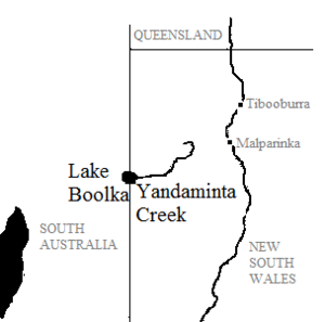
Yandaminta Creek is a special waterway in Far West New South Wales. It's an ephemeral stream, which means it only flows after it rains a lot. Imagine a river that sometimes disappears!
This creek starts near a town called Milparinka. It then travels all the way to the border of South Australia. Here, it flows into a lake called Lake Boolka.
Yandaminta Creek is located in the state of New South Wales. This is in the central part of Australia. It's about 1,000 km northwest of Canberra, the capital city. The creek begins at a height of 216 meters above sea level. Over its 159 km journey, it drops about 128 meters. It finally enters Lake Boolka at a height of 88.4 meters.
Contents
Exploring Yandaminta Creek's Location
Yandaminta Creek is found in a very quiet part of Australia. This area is almost empty, with fewer than two people living in each square kilometer. It's a vast, flat, and dry desert landscape.
Climate and Weather Around the Creek
The area around Yandaminta Creek has a hot desert climate. This means it's usually very warm and dry. The average temperature for the year is 23 °C.
The hottest month is January, when the average temperature can reach 34 °C. The coolest month is June, with an average temperature of 10 °C.
It doesn't rain much here. The area gets about 306 millimeters of rain each year. February is the wettest month, with about 109 mm of rain. October is the driest, receiving only about 1 mm of rain.
Plants and Wildlife in the Desert
Even though it's a dry place, many plants grow around Yandaminta Creek. Most of the area is covered by Mulga (Acacia aneura) shrubland. These are small, bushy trees that are very tough.
Along the main watercourses, you can find River Red Gum trees (Eucalyptus camaldulensis). These tall trees love water and grow where the creek flows. The flat areas that sometimes flood have different types of saltbush and native grasses.
In some shallow, wet spots, you might see Lignum (Muehlenbeckia cunninghamii) and Canegrass (Eragrastis australasica). These plants are special because they can live in areas that are wet for a while and then dry out.
What Does "Yandaminta" Mean?
The name "Yandaminta" comes from local Aboriginal languages. It can be understood as "yarnta" meaning "stone" and "mintha" which is a neutral ending. So, the name might relate to the stony landscape of the area.
 | Dorothy Vaughan |
 | Charles Henry Turner |
 | Hildrus Poindexter |
 | Henry Cecil McBay |


