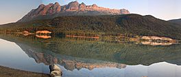
Yellowhead Lake facts for kids
Quick facts for kids Yellowhead Lake |
|
|---|---|
 |
|
| Location | Mount Robson Provincial Park |
| Coordinates | 52°52′00″N 118°32′00″W / 52.86667°N 118.53333°W |
| Primary inflows | Yellowhead Creek, Rockingham Creek |
| Primary outflows | Yellowhead Creek |
| Basin countries | Canada |
| Max. length | 5.6 km (3.5 mi) |
| Surface elevation | 3,635 feet (1,108 m) |
| Islands | None |
| Settlements | None |
Yellowhead Lake is a cool lake with a unique, wiggly shape. You can find it in Mount Robson Provincial Park, about 3.7 kilometers (2.3 miles) southwest of Yellowhead Pass. This lake is part of Yellowhead Creek, a big stream that eventually flows into the mighty Fraser River. The Fraser River then continues past Moose Lake.
What Makes Yellowhead Lake Special?
Yellowhead Lake truly has a one-of-a-kind shape! It stretches about 5.6 kilometers (3.5 miles) long. Its width changes quite a bit depending on where you are on the lake.
The lake gets its water from Yellowhead Creek at its northeast end. This creek flows through some swampy areas before reaching the lake. Another fast-flowing stream, Rockingham Creek, also joins the lake about a quarter of the way down its southern side. Yellowhead Creek then leaves the lake at its southwestern end. It soon reaches the Fraser River after passing under the Yellowhead Highway.
How Yellowhead Lake Got Its Name
Yellowhead Lake has had a few different names over the years! In 1824, a governor from the Hudson's Bay Company, George Simpson, called it Cranberry Lake. He was on his way to Athabasca Pass at the time.
Later, in 1863, some gold seekers called Overlanders gave it a very unusual name: Buffalo Dung Lake. Finally, in 1872, the lake received its current name. George Grant suggested naming it after the nearby Yellowhead Pass.
 | Victor J. Glover |
 | Yvonne Cagle |
 | Jeanette Epps |
 | Bernard A. Harris Jr. |


