
Yocalla Municipality facts for kids
Quick facts for kids
Yocalla Municipality
|
|
|---|---|
|
Municipality
|
|

Cordillera de los Frailes, looking west. Pari Chata (Yocalla Municipality) is on the right in the background, left of it is the Pillku Mayu valley.
|
|

Location within Potosí Department
|
|

Yocalla Municipality
Location in Bolivia
|
|
| Country | |
| Department | Potosí Department |
| Province | Tomás Frías Province |
| Seat | Yocalla |
| Population
(2001)
|
|
| • Total | 8,046 |
| • Ethnicities | Quechua |
| Time zone | UTC-4 (BOT) |
Yocalla Municipality is a local government area in Bolivia. It is part of the Tomás Frías Province in the Potosí Department. The main town, or "seat," of this municipality is called Yocalla.
Contents
Exploring Yocalla's Mountains
Yocalla Municipality is home to some impressive mountains. Here are some of the highest peaks you can find there:
- Achakana
- Chawpi Urqu
- Jalsuri
- Jatun Pampa
- Jatun Qaqa
- Jatun Q'asa
- Kuntur Nasa
- Kunturiri
- Pari Chata
- Puka Urqu
- T'ula P'ujru
- Waylla Qullu
- Waylla Q'asa
- Wichhu Qullu
- Wila Salla
- Wila Sirka
How Yocalla is Divided
A municipality is often divided into smaller areas called cantons. Yocalla Municipality has three main cantons:
- Salinas de Yocalla
- Santa Lucia
- Yocalla
The People of Yocalla
Most people living in Yocalla Municipality are indigenous. Many of them are from the Quechua group.
Here's a look at the different ethnic groups in the municipality, based on a 2001 count:
| Ethnic Group | % |
|---|---|
| Quechua | 93.8 |
| Aymara | 0.4 |
| Guaraní, Chiquitos, Moxos | 0.1 |
| Not indigenous | 5.7 |
| Other indigenous groups | 0.1 |
Images for kids
-
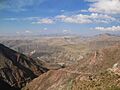
Cordillera de los Frailes, looking west. Pari Chata (Yocalla Municipality) is on the right in the background, left of it is the Pillku Mayu valley.
-
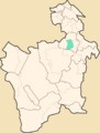
Location within Potosí Department
See also
 In Spanish: Yocalla para niños
