
Zestaponi Municipality facts for kids
Quick facts for kids
Zestaponi Municipality
ზესტაფონის მუნიციპალიტეტი
|
|||
|---|---|---|---|
|
Municipality
|
|||

Tabakini Church near Argveti
|
|||
|
|||

Location of the municipality within Georgia
|
|||
| Country | |||
| Region | Imereti | ||
| Capital | Zestaponi | ||
| Government | |||
| • Type | Mayor–Council | ||
| • Body | Zestaponi Municipal Assembly | ||
| Area | |||
| • Total | 423 km2 (163 sq mi) | ||
| Population
(2014)
|
|||
| • Total | 57,628 | ||
| Population by ethnicity | |||
| • Georgians | 99.5 % | ||
| • Russians | 0.2 % | ||
| • Armenians | 0.1 % | ||
| • Ukrainians | 0.1 % | ||
| Time zone | UTC+4 (Georgian Standard Time) | ||


Zestaponi or Zestafoni is a municipality in the country of Georgia. It is located in the Imereti region. A municipality is like a local government area.
This area covers about 423 square kilometers. In 2014, about 57,628 people lived here. The main town is also called Zestaponi. It is an important place for factories. There is a large factory that makes special metals. These metals come from a rock called manganese ore. This ore is found nearby in Chiatura. The Zestaponi area is also famous for growing grapes and making wine.
Contents
Geography and Climate
Land Features of Zestaponi
The western part of Zestaponi Municipality is a low area. It is called the Kolkheti lowlands. This land is about 90 to 200 meters above sea level. As you go east, the land gets higher. It rises to the Imereti plateau, which is about 500 meters high. This area has many hills and narrow, rocky valleys. To the south, there are low mountains. These mountains are about 1,000 meters high.
Weather in the Region
The lowlands have cold winters. The average temperature in January is about -4 °C. Summers are hot, with an average of 24 °C in August. The area gets about 1190 mm of rain each year. In the higher mountain areas, it is cooler and rains more often.
Rivers and Waterways
The Kvirila River flows through the region. It runs from east to west. Many smaller rivers flow into the Kvirila River. Because of these rivers, flooding is common in the spring.
Plants and Animals
The municipality has many forests. You can find trees like hornbeam, oak, beech, and chestnut. There are also alder trees and many other types. The southern mountains have beech, maple, and Imeretian oak trees. Some parts of the lowlands and hills have been cleared for farming. But the southern mountains are still very thick with trees. These forests are home to many animals. You might see wolves, foxes, jackals, badgers, and rabbits. There are also many smaller animals living here.
Towns and Villages
Main Towns and Industry
The town of Zestaponi and the nearby town of Shorapani are important for factories. The Zestaponi factory makes special metal alloys. It uses manganese ore that comes from Chiatura by train. This factory makes a lot of these metals. It supplies about 6% of the world's demand. It is the biggest factory of its kind in Georgia. In the past, during the Soviet era, there were even more factories. However, many of them have now closed.
Life in Rural Areas
The rural areas of Zestaponi Municipality have many communities. Some of these include Boslevi, Dilikauri, and Kveda Sakara. Each community usually has two or three villages. These villages have a rich history. You can find old castles in some villages. For example, there are Shorapani and Sviri castles in Argveti. There is also a very old castle from the 6th or 7th century in Tabakini. Many old churches and ancient wine cellars can also be found. These places are interesting for visitors.
Farming and Wine Production
Zestaponi Municipality is a big farming area. It has about 5,000 hectares of vineyards. This means that 80% of all the farmland is used for growing grapes! The Sakara Viticulture and Winemaking Scientific-Research Station is very important. It helps to improve grape growing and wine making in the region. Farmers also grow other crops like corn and vegetables. Raising cattle and pigs is also common here.
Largest Settlements
Here are the main towns and villages in the Zestaponi area, listed by how many people live there:
| Rank | Settlement | Population |
|---|---|---|
| 1 | Zestaponi | 20 814 |
| 2 | Zeda Sakara | 2 099 |
| 3 | Kveda Sakara | 1 989 |
| 4 | Puti | 1 564 |
| 5 | Zovreti | 1 513 |
| 6 | Shorapani | 1 258 |
Gallery
-
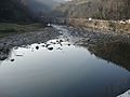
River near Shrosha, Zestaponi
-
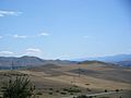
Landscape near Puti
-
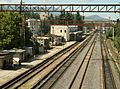
Zestaponi railway station
-
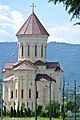
Orthodox church in Zestaponi

.jpg)
.jpg)

See also
 In Spanish: Municipio de Zestafoni para niños
